Saint-Laurent-sur-Saône geodata
Saint-Laurent-sur-Saône (Auvergne-Rhône-Alpes) is a populated place; located in France in Europe/Paris (GMT+2) time zone. With population of 1,798 people, there are 5280 cities with bigger population in this country. Compared to other cities in France, 62.2% of cities are located further ↑North; 75.7% of cities are located further ←West and 61.6% of cities have lower elevation than Saint-Laurent-sur-Saône. Note1
Administrative division(s):
- Level 1: Auvergne-Rhône-Alpes
- Level 2: Département de l'Ain
- Level 3: Arrondissement de Bourg-en-Bresse
- Level 4: Saint-Laurent-sur-Saône
Current local time in Saint-Laurent-sur-Saône:
05:25 PM, SaturdayDifference from your time zone: hours


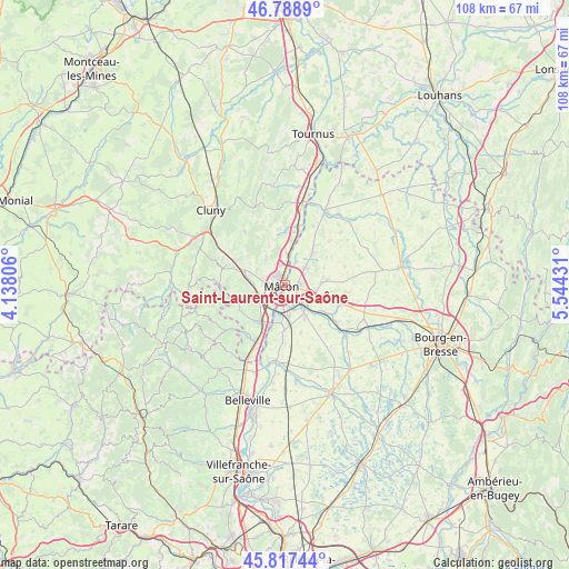
Saint-Laurent-sur-Saône GPS coordinates[2]
46° 18' 19.152" North, 4° 50' 28.284" East
| Map corner | latitude | longitude |
|---|---|---|
| Upper-left | 46.7889°, | 4.13806° |
| Center: | 46.30532°, | 4.84119° |
| Lower-right: | 45.81744°, | 5.54431° |
| Map W x H: | 108×108 km | = 67.1×67.1mi |
| max Lat: | 51.07786° ⇑62.2% North |
| Saint-Laurent-sur-Saône: | 46.30532° |
| min Lat: | ⇓37.8% South 41.3874° |
| min Long | Saint-Laurent-s | max Long |
| -5.08615° | 4.84119° | 9.52242° |
| W 75.7%⇐ | ⇒24.3% E |
Elevation
Elevation of Saint-Laurent-sur-Saône is 178 m = 584 ft, and this is 15.7 m = 52 ft below average elevation for this country.
| Max E: |
2333 m = 7654 ft | 38.4% |
| Avg. | 193.7 m = 635 ft | |
| Saint-Laurent-sur-Saône | 178 m = 584 ft | |
Min E: |
-1 m = -3 ft | 61.6% |
See also: France elevation on elevation.city.
Geographical zone
Saint-Laurent-sur-Saône is located in North temperate zone (between Tropic of Cancer and the Arctic Circle). Distance of this North polar circle is 2252.5 km =1399.6 mi to North.| Distance of | km | miles | from Saint-Laurent-sur-Saône |
|---|---|---|---|
| North Pole | 4858.4 | 3018.9 | to North |
| Arctic Circle | 2252.5 | 1399.6 | to North |
| Tropic Cancer | 2542.7 | 1580 | to South |
| Equator | 5148.7 | 3199.3 | to South |


Nearby cities:
15 places around Saint-Laurent-sur-Saône: (largest is in red/bold)
• Bâgé-le-Châtel
7 km =4.3 mi,  86°
86°
• Charnay-lès-Mâcon
4.3 km =2.7 mi,  273°
273°
• Cormoranche-sur-Saône
7.6 km =4.7 mi,  183°
183°
• Crottet
5.2 km =3.2 mi,  128°
128°
• Davayé
7.5 km =4.7 mi, 268°
• Feillens
5 km =3.1 mi,  50°
50°
• Grièges
5.5 km =3.4 mi,  174°
174°
• Hurigny
5.8 km =3.6 mi,  323°
323°
• Laiz
7.1 km =4.4 mi,  148°
148°
• Mâcon
1.4 km =0.9 mi,  314°
314°
• Pont-de-Veyle
6 km =3.7 mi,  144°
144°
• Replonges
3.3 km =2.1 mi,  98°
98°
• Saint-André-de-Bâgé
6.3 km =3.9 mi, 94°
• Sancé
3.9 km =2.4 mi,  347°
347°
• Vinzelles
6.6 km =4.1 mi,  237°
237°
Sources, notices
• [Note1] Compared only with cities in France existing in our database
• [Src1] Map data: © OpenStreetMap contributors (CC-BY-SA)
• [Src2] Other city data from geonames.org with taken over terms of usage.
• [Src3] Geographical zone / Annual Mean Temperature by Robert A. Rohde @ Wikipedia
