Sallertaine geodata
Sallertaine (Pays de la Loire) is a populated place; located in France in Europe/Paris (GMT+2) time zone. With population of 2,410 people, there are 4013 cities with bigger population in this country. Compared to other cities in France, 56.6% of cities are located further ↑North; 94.7% of cities are located further →East and 99.6% of cities have higher elevation than Sallertaine. Note1
Administrative division(s):
- Level 1: Pays de la Loire
- Level 2: Département de la Vendée
- Level 3: Arrondissement des Sables-d'Olonne
- Level 4: Sallertaine


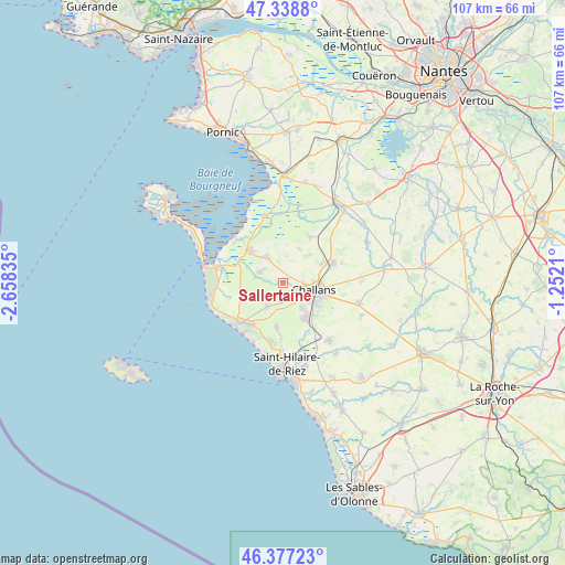
Sallertaine GPS coordinates[2]
46° 51' 36.612" North, 1° 57' 18.792" West
| Map corner | latitude | longitude |
|---|---|---|
| Upper-left | 47.3388°, | -2.65835° |
| Center: | 46.86017°, | -1.95522° |
| Lower-right: | 46.37723°, | -1.2521° |
| Map W x H: | 106.9×106.9 km | = 66.4×66.4mi |
| max Lat: | 51.07786° ⇑56.6% North |
| Sallertaine: | 46.86017° |
| min Lat: | ⇓43.4% South 41.3874° |
| min Long | Sallertaine | max Long |
| -5.08615° | -1.95522° | 9.52242° |
| W 5.3%⇐ | ⇒94.7% E |
Elevation
Elevation of Sallertaine is 4 m = 13 ft, and this is 189.7 m = 622 ft below average elevation for this country.
| Max E: |
2333 m = 7654 ft | 99.6% |
| Avg. | 193.7 m = 635 ft | |
| Sallertaine | 4 m = 13 ft | |
Min E: |
-1 m = -3 ft | 0.4% |
See also: France elevation on elevation.city.
Geographical zone
Sallertaine is located in North temperate zone (between Tropic of Cancer and the Arctic Circle). Distance of this North polar circle is 2190.8 km =1361.3 mi to North.| Distance of | km | miles | from Sallertaine |
|---|---|---|---|
| North Pole | 4796.7 | 2980.5 | to North |
| Arctic Circle | 2190.8 | 1361.3 | to North |
| Tropic Cancer | 2604.4 | 1618.3 | to South |
| Equator | 5210.4 | 3237.6 | to South |


Nearby cities:
15 places around Sallertaine: (largest is in red/bold)
• Beauvoir-sur-Mer
8.8 km =5.5 mi,  311°
311°
• Bois-de-Cené
10 km =6.2 mi,  31°
31°
• Bouin
13 km =8.1 mi,  345°
345°
• Challans
6.4 km =4 mi,  106°
106°
• Châteauneuf
7.1 km =4.4 mi,  23°
23°
• Commequiers
14.2 km =8.8 mi,  141°
141°
• La Barre-de-Monts
12.9 km =8 mi,  280°
280°
• La Garnache
10 km =6.2 mi,  69°
69°
• Le Perrier
5.4 km =3.4 mi,  212°
212°
• Notre-Dame-de-Monts
13.8 km =8.6 mi,  256°
256°
• Notre-Dame-de-Riez
13.3 km =8.3 mi,  164°
164°
• Saint-Gervais
5.8 km =3.6 mi,  322°
322°
• Saint-Jean-de-Monts
12.4 km =7.7 mi,  231°
231°
• Saint-Urbain
4.5 km =2.8 mi,  292°
292°
• Soullans
8.2 km =5.1 mi,  149°
149°
Sources, notices
• [Note1] Compared only with cities in France existing in our database
• [Src1] Map data: © OpenStreetMap contributors (CC-BY-SA)
• [Src2] Other city data from geonames.org with taken over terms of usage.
• [Src3] Geographical zone / Annual Mean Temperature by Robert A. Rohde @ Wikipedia
