Soullans geodata
Soullans (Pays de la Loire) is a populated place; located in France in Europe/Paris (GMT+2) time zone. With population of 3,676 people, there are 2672 cities with bigger population in this country. Compared to other cities in France, 57.2% of cities are located further ↑North; 94.5% of cities are located further →East and 97.4% of cities have higher elevation than Soullans. Note1
Administrative division(s):
- Level 1: Pays de la Loire
- Level 2: Département de la Vendée
- Level 3: Arrondissement des Sables-d'Olonne
- Level 4: Soullans


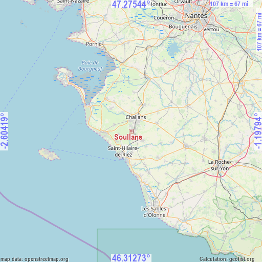
Soullans GPS coordinates[2]
46° 47' 46.464" North, 1° 54' 3.816" West
| Map corner | latitude | longitude |
|---|---|---|
| Upper-left | 47.27544°, | -2.60419° |
| Center: | 46.79624°, | -1.90106° |
| Lower-right: | 46.31273°, | -1.19794° |
| Map W x H: | 107×107 km | = 66.5×66.5mi |
| max Lat: | 51.07786° ⇑57.2% North |
| Soullans: | 46.79624° |
| min Lat: | ⇓42.8% South 41.3874° |
| min Long | Soullans | max Long |
| -5.08615° | -1.90106° | 9.52242° |
| W 5.5%⇐ | ⇒94.5% E |
Elevation
Elevation of Soullans is 10 m = 33 ft, and this is 183.7 m = 603 ft below average elevation for this country.
| Max E: |
2333 m = 7654 ft | 97.4% |
| Avg. | 193.7 m = 635 ft | |
| Soullans | 10 m = 33 ft | |
Min E: |
-1 m = -3 ft | 2.6% |
See also: France elevation on elevation.city.
Geographical zone
Soullans is located in North temperate zone (between Tropic of Cancer and the Arctic Circle). Distance of this North polar circle is 2197.9 km =1365.7 mi to North.| Distance of | km | miles | from Soullans |
|---|---|---|---|
| North Pole | 4803.8 | 2984.9 | to North |
| Arctic Circle | 2197.9 | 1365.7 | to North |
| Tropic Cancer | 2597.3 | 1613.9 | to South |
| Equator | 5203.3 | 3233.2 | to South |


Nearby cities:
15 places around Soullans: (largest is in red/bold)
• Apremont
13.3 km =8.3 mi,  113°
113°
• Challans
5.6 km =3.5 mi,  20°
20°
• Commequiers
6.2 km =3.9 mi,  130°
130°
• Froidfond
13.6 km =8.5 mi,  53°
53°
• La Garnache
11.9 km =7.4 mi,  26°
26°
• Le Fenouiller
8.6 km =5.3 mi,  180°
180°
• Le Perrier
7.5 km =4.7 mi,  290°
290°
• Notre-Dame-de-Riez
5.8 km =3.6 mi,  185°
185°
• Saint-Christophe-du-Ligneron
10.8 km =6.7 mi,  72°
72°
• Saint-Gilles-Croix-de-Vie
11.5 km =7.1 mi,  197°
197°
• Saint-Hilaire-de-Riez
9.4 km =5.8 mi, 191°
• Saint-Maixent-sur-Vie
8.6 km =5.3 mi,  136°
136°
• Saint-Révérend
12.1 km =7.5 mi,  153°
153°
• Saint-Urbain
12.1 km =7.5 mi,  316°
316°
• Sallertaine
8.2 km =5.1 mi,  329°
329°
Sources, notices
• [Note1] Compared only with cities in France existing in our database
• [Src1] Map data: © OpenStreetMap contributors (CC-BY-SA)
• [Src2] Other city data from geonames.org with taken over terms of usage.
• [Src3] Geographical zone / Annual Mean Temperature by Robert A. Rohde @ Wikipedia
