Bois-de-Cené geodata
Bois-de-Cené (Pays de la Loire) is a populated place; located in France in Europe/Paris (GMT+2) time zone. With population of 1,364 people, there are 6749 cities with bigger population in this country. Compared to other cities in France, 55.9% of cities are located further ↑North; 94.4% of cities are located further →East and 97.8% of cities have higher elevation than Bois-de-Cené. Note1
Administrative division(s):
- Level 1: Pays de la Loire
- Level 2: Département de la Vendée
- Level 3: Arrondissement des Sables-d'Olonne
- Level 4: Bois-de-Céné


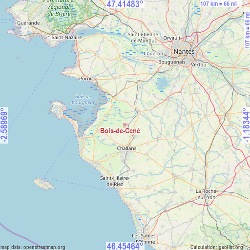
Bois-de-Cené GPS coordinates[2]
46° 56' 12.804" North, 1° 53' 11.616" West
| Map corner | latitude | longitude |
|---|---|---|
| Upper-left | 47.41483°, | -2.58969° |
| Center: | 46.93689°, | -1.88656° |
| Lower-right: | 46.45464°, | -1.18344° |
| Map W x H: | 106.8×106.8 km | = 66.4×66.4mi |
| max Lat: | 51.07786° ⇑55.9% North |
| Bois-de-Cené: | 46.93689° |
| min Lat: | ⇓44.1% South 41.3874° |
| min Long | Bois-de-Cené | max Long |
| -5.08615° | -1.88656° | 9.52242° |
| W 5.6%⇐ | ⇒94.4% E |
Elevation
Elevation of Bois-de-Cené is 9 m = 30 ft, and this is 184.7 m = 606 ft below average elevation for this country.
| Max E: |
2333 m = 7654 ft | 97.8% |
| Avg. | 193.7 m = 635 ft | |
| Bois-de-Cené | 9 m = 30 ft | |
Min E: |
-1 m = -3 ft | 2.2% |
See also: France elevation on elevation.city.
Geographical zone
Bois-de-Cené is located in North temperate zone (between Tropic of Cancer and the Arctic Circle). Distance of this North polar circle is 2182.3 km =1356 mi to North.| Distance of | km | miles | from Bois-de-Cené |
|---|---|---|---|
| North Pole | 4788.2 | 2975.2 | to North |
| Arctic Circle | 2182.3 | 1356 | to North |
| Tropic Cancer | 2613 | 1623.6 | to South |
| Equator | 5218.9 | 3242.9 | to South |


Nearby cities:
15 places around Bois-de-Cené: (largest is in red/bold)
• Beauvoir-sur-Mer
12.1 km =7.5 mi,  257°
257°
• Bouin
9.4 km =5.8 mi,  295°
295°
• Bourgneuf-en-Retz
12.6 km =7.8 mi,  337°
337°
• Challans
10.4 km =6.5 mi,  175°
175°
• Châteauneuf
3.1 km =1.9 mi,  229°
229°
• Fresnay-en-Retz
9.8 km =6.1 mi,  4°
4°
• Froidfond
12.4 km =7.7 mi,  127°
127°
• La Garnache
6.5 km =4 mi,  140°
140°
• Machecoul
7.9 km =4.9 mi,  37°
37°
• Paulx
10.3 km =6.4 mi,  74°
74°
• Saint-Gervais
9.6 km =6 mi,  245°
245°
• Saint-Même-le-Tenu
11.6 km =7.2 mi, 37°
• Saint-Urbain
11.6 km =7.2 mi, 233°
• Saint-Étienne-de-Mer-Morte
11 km =6.8 mi,  94°
94°
• Sallertaine
10 km =6.2 mi,  211°
211°
Sources, notices
• [Note1] Compared only with cities in France existing in our database
• [Src1] Map data: © OpenStreetMap contributors (CC-BY-SA)
• [Src2] Other city data from geonames.org with taken over terms of usage.
• [Src3] Geographical zone / Annual Mean Temperature by Robert A. Rohde @ Wikipedia
