Challans geodata
Challans (Pays de la Loire) is a populated place; located in France in Europe/Paris (GMT+2) time zone. With population of 18,947 people, there are 490 cities with bigger population in this country. Compared to other cities in France, 56.7% of cities are located further ↑North; 94.4% of cities are located further →East and 97% of cities have higher elevation than Challans. Note1
Administrative division(s):
- Level 1: Pays de la Loire
- Level 2: Département de la Vendée
- Level 3: Arrondissement des Sables-d'Olonne
- Level 4: Challans


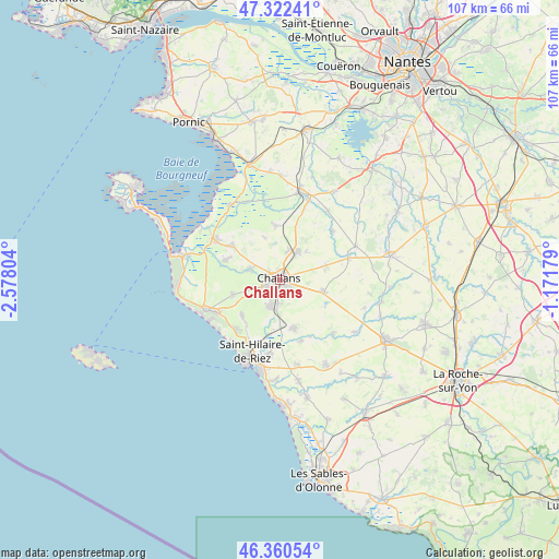
Challans GPS coordinates[2]
46° 50' 37.068" North, 1° 52' 29.676" West
| Map corner | latitude | longitude |
|---|---|---|
| Upper-left | 47.32241°, | -2.57804° |
| Center: | 46.84363°, | -1.87491° |
| Lower-right: | 46.36054°, | -1.17179° |
| Map W x H: | 106.9×106.9 km | = 66.4×66.4mi |
| max Lat: | 51.07786° ⇑56.7% North |
| Challans: | 46.84363° |
| min Lat: | ⇓43.3% South 41.3874° |
| min Long | Challans | max Long |
| -5.08615° | -1.87491° | 9.52242° |
| W 5.6%⇐ | ⇒94.4% E |
Elevation
Elevation of Challans is 11 m = 36 ft, and this is 182.7 m = 599 ft below average elevation for this country.
| Max E: |
2333 m = 7654 ft | 97% |
| Avg. | 193.7 m = 635 ft | |
| Challans | 11 m = 36 ft | |
Min E: |
-1 m = -3 ft | 3% |
See also: France elevation on elevation.city.
Geographical zone
Challans is located in North temperate zone (between Tropic of Cancer and the Arctic Circle). Distance of this North polar circle is 2192.7 km =1362.5 mi to North.| Distance of | km | miles | from Challans |
|---|---|---|---|
| North Pole | 4798.5 | 2981.6 | to North |
| Arctic Circle | 2192.7 | 1362.5 | to North |
| Tropic Cancer | 2602.6 | 1617.2 | to South |
| Equator | 5208.5 | 3236.4 | to South |


Nearby cities:
15 places around Challans: (largest is in red/bold)
• Bois-de-Cené
10.4 km =6.5 mi,  355°
355°
• Châteauneuf
9 km =5.6 mi,  339°
339°
• Commequiers
9.6 km =6 mi,  163°
163°
• Falleron
13.8 km =8.6 mi,  72°
72°
• Froidfond
9.4 km =5.8 mi, 72°
• La Garnache
6.3 km =3.9 mi,  31°
31°
• Le Perrier
9.4 km =5.8 mi,  253°
253°
• Notre-Dame-de-Riez
11.3 km =7 mi,  193°
193°
• Saint-Christophe-du-Ligneron
8.6 km =5.3 mi,  104°
104°
• Saint-Gervais
11.6 km =7.2 mi,  303°
303°
• Saint-Maixent-sur-Vie
12.2 km =7.6 mi, 161°
• Saint-Urbain
10.8 km =6.7 mi,  289°
289°
• Saint-Étienne-de-Mer-Morte
13.8 km =8.6 mi,  46°
46°
• Sallertaine
6.4 km =4 mi, 286°
• Soullans
5.6 km =3.5 mi,  200°
200°
Sources, notices
• [Note1] Compared only with cities in France existing in our database
• [Src1] Map data: © OpenStreetMap contributors (CC-BY-SA)
• [Src2] Other city data from geonames.org with taken over terms of usage.
• [Src3] Geographical zone / Annual Mean Temperature by Robert A. Rohde @ Wikipedia
