Saint-Vincent-du-Lorouër geodata
Saint-Vincent-du-Lorouër (Pays de la Loire) is a populated place; located in France in Europe/Paris (GMT+2) time zone. With population of 900 people, there are 9657 cities with bigger population in this country. Compared to other cities in France, 56.2% of cities are located further ↓South; 73.5% of cities are located further →East and 68.7% of cities have higher elevation than Saint-Vincent-du-Lorouër. Note1
Administrative division(s):
- Level 1: Pays de la Loire
- Level 2: Sarthe
- Level 3: Arrondissement de La Flèche
- Level 4: Saint-Vincent-du-Lorouër
Current local time in Saint-Vincent-du-Lorouër:
02:57 PM, MondayDifference from your time zone: hours


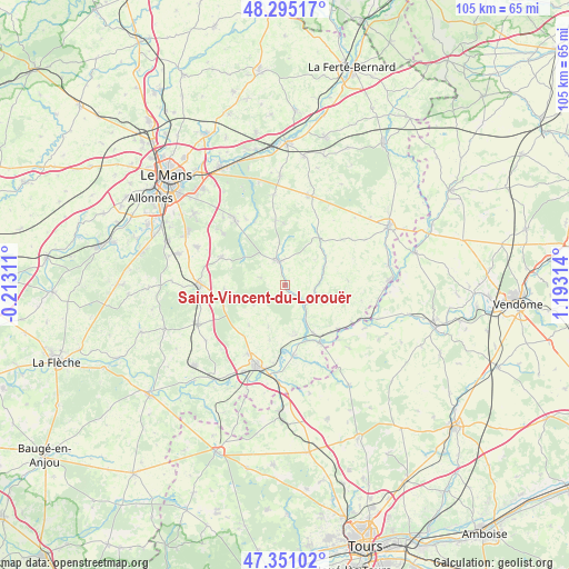
Saint-Vincent-du-Lorouër GPS coordinates[2]
47° 49' 30.864" North, 0° 29' 24.072" East
| Map corner | latitude | longitude |
|---|---|---|
| Upper-left | 48.29517°, | -0.21311° |
| Center: | 47.82524°, | 0.49002° |
| Lower-right: | 47.35102°, | 1.19314° |
| Map W x H: | 105×105 km | = 65.2×65.2mi |
| max Lat: | 51.07786° ⇑43.8% North |
| Saint-Vincent-du-Lorouër: | 47.82524° |
| min Lat: | ⇓56.2% South 41.3874° |
| min Long | Saint-Vincent-d | max Long |
| -5.08615° | 0.49002° | 9.52242° |
| W 26.5%⇐ | ⇒73.5% E |
Elevation
Elevation of Saint-Vincent-du-Lorouër is 81 m = 266 ft, and this is 112.7 m = 370 ft below average elevation for this country.
| Max E: |
2333 m = 7654 ft | 68.7% |
| Avg. | 193.7 m = 635 ft | |
| Saint-Vincent-du-Lorouër | 81 m = 266 ft | |
Min E: |
-1 m = -3 ft | 31.3% |
See also: France elevation on elevation.city.
Geographical zone
Saint-Vincent-du-Lorouër is located in North temperate zone (between Tropic of Cancer and the Arctic Circle). Distance of this North polar circle is 2083.5 km =1294.6 mi to North.| Distance of | km | miles | from Saint-Vincent-du-Lorouër |
|---|---|---|---|
| North Pole | 4689.4 | 2913.9 | to North |
| Arctic Circle | 2083.5 | 1294.6 | to North |
| Tropic Cancer | 2711.7 | 1685 | to South |
| Equator | 5317.7 | 3304.3 | to South |


Nearby cities:
15 places around Saint-Vincent-du-Lorouër: (largest is in red/bold)
• Chahaignes
9.5 km =5.9 mi,  169°
169°
• Challes
13 km =8.1 mi,  334°
334°
• Courdemanche
5.5 km =3.4 mi,  101°
101°
• Flée
10.6 km =6.6 mi,  195°
195°
• Jupilles
6.9 km =4.3 mi,  236°
236°
• La Chartre-sur-le-Loir
12 km =7.5 mi,  150°
150°
• Le Grand-Lucé
4.8 km =3 mi,  341°
341°
• Lhomme
10.4 km =6.5 mi, 150°
• Luceau
14.4 km =8.9 mi,  208°
208°
• Marigné-Laillé
11.2 km =7 mi,  265°
265°
• Marçon
12.8 km =8 mi, 172°
• Ruillé-sur-Loir
12.8 km =8 mi,  130°
130°
• Saint-Mars-d’Outillé
12.8 km =8 mi,  293°
293°
• Villaines-sous-Lucé
4.5 km =2.8 mi,  351°
351°
• Volnay
12.1 km =7.5 mi, 352°
Sources, notices
• [Note1] Compared only with cities in France existing in our database
• [Src1] Map data: © OpenStreetMap contributors (CC-BY-SA)
• [Src2] Other city data from geonames.org with taken over terms of usage.
• [Src3] Geographical zone / Annual Mean Temperature by Robert A. Rohde @ Wikipedia
