Chahaignes geodata
Chahaignes (Pays de la Loire) is a populated place; located in France in Europe/Paris (GMT+2) time zone. With population of 787 people, there are 10744 cities with bigger population in this country. Compared to other cities in France, 54.8% of cities are located further ↓South; 73.3% of cities are located further →East and 73.6% of cities have higher elevation than Chahaignes. Note1
Administrative division(s):
- Level 1: Pays de la Loire
- Level 2: Sarthe
- Level 3: Arrondissement de La Flèche
- Level 4: Chahaignes


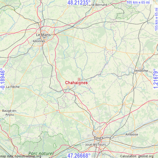
Chahaignes GPS coordinates[2]
47° 44' 29.976" North, 0° 30' 49.212" East
| Map corner | latitude | longitude |
|---|---|---|
| Upper-left | 48.21235°, | -0.18946° |
| Center: | 47.74166°, | 0.51367° |
| Lower-right: | 47.26668°, | 1.21679° |
| Map W x H: | 105.1×105.1 km | = 65.3×65.3mi |
| max Lat: | 51.07786° ⇑45.2% North |
| Chahaignes: | 47.74166° |
| min Lat: | ⇓54.8% South 41.3874° |
| min Long | Chahaignes | max Long |
| -5.08615° | 0.51367° | 9.52242° |
| W 26.7%⇐ | ⇒73.3% E |
Elevation
Elevation of Chahaignes is 70 m = 230 ft, and this is 123.7 m = 406 ft below average elevation for this country.
| Max E: |
2333 m = 7654 ft | 73.6% |
| Avg. | 193.7 m = 635 ft | |
| Chahaignes | 70 m = 230 ft | |
Min E: |
-1 m = -3 ft | 26.4% |
See also: France elevation on elevation.city.
Geographical zone
Chahaignes is located in North temperate zone (between Tropic of Cancer and the Arctic Circle). Distance of this North polar circle is 2092.8 km =1300.4 mi to North.| Distance of | km | miles | from Chahaignes |
|---|---|---|---|
| North Pole | 4698.7 | 2919.6 | to North |
| Arctic Circle | 2092.8 | 1300.4 | to North |
| Tropic Cancer | 2702.5 | 1679.3 | to South |
| Equator | 5308.4 | 3298.5 | to South |


Nearby cities:
15 places around Chahaignes: (largest is in red/bold)
• Chemillé-sur-Dême
13.7 km =8.5 mi,  132°
132°
• Château-du-Loir
8.8 km =5.5 mi,  233°
233°
• Courdemanche
8.9 km =5.5 mi,  23°
23°
• Dissay-sous-Courcillon
9.1 km =5.7 mi,  199°
199°
• Flée
4.6 km =2.9 mi,  258°
258°
• Jupilles
9.3 km =5.8 mi,  305°
305°
• La Chartre-sur-le-Loir
4.3 km =2.7 mi,  105°
105°
• Lhomme
3.4 km =2.1 mi,  86°
86°
• Luceau
9.3 km =5.8 mi,  249°
249°
• Marçon
3.5 km =2.2 mi,  183°
183°
• Montabon
11.7 km =7.3 mi,  236°
236°
• Ruillé-sur-Loir
8.1 km =5 mi,  82°
82°
• Saint-Vincent-du-Lorouër
9.5 km =5.9 mi,  349°
349°
• Villaines-sous-Lucé
13.9 km =8.6 mi, 350°
• Vouvray-sur-Loir
6.4 km =4 mi,  216°
216°
Sources, notices
• [Note1] Compared only with cities in France existing in our database
• [Src1] Map data: © OpenStreetMap contributors (CC-BY-SA)
• [Src2] Other city data from geonames.org with taken over terms of usage.
• [Src3] Geographical zone / Annual Mean Temperature by Robert A. Rohde @ Wikipedia
