Oradour-sur-Glane geodata
Oradour-sur-Glane (Nouvelle-Aquitaine) is a populated place; located in France in Europe/Paris (GMT+2) time zone. With population of 2,088 people, there are 4613 cities with bigger population in this country. Compared to other cities in France, 67.1% of cities are located further ↑North; 68.5% of cities are located further →East and 76.4% of cities have lower elevation than Oradour-sur-Glane. Note1
Administrative division(s):
- Level 1: Nouvelle-Aquitaine
- Level 2: Haute-Vienne
- Level 3: Arrondissement de Rochechouart
- Level 4: Oradour-sur-Glane


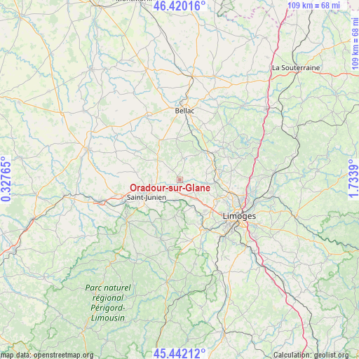
Oradour-sur-Glane GPS coordinates[2]
45° 55' 59.88" North, 1° 1' 50.808" East
| Map corner | latitude | longitude |
|---|---|---|
| Upper-left | 46.42016°, | 0.32765° |
| Center: | 45.9333°, | 1.03078° |
| Lower-right: | 45.44212°, | 1.7339° |
| Map W x H: | 108.7×108.7 km | = 67.5×67.5mi |
| max Lat: | 51.07786° ⇑67.1% North |
| Oradour-sur-Glane: | 45.9333° |
| min Lat: | ⇓32.9% South 41.3874° |
| min Long | Oradour-sur-Gla | max Long |
| -5.08615° | 1.03078° | 9.52242° |
| W 31.5%⇐ | ⇒68.5% E |
Elevation
Elevation of Oradour-sur-Glane is 259 m = 850 ft, and this is 65.3 m = 214 ft above average elevation for this country.
| Max E: |
2333 m = 7654 ft | 23.6% |
| Oradour-sur-Glane | 259 m 850 ft | |
| Avg. | 193.7 m = 635 ft | |
Min E: |
-1 m = -3 ft | 76.4% |
See also: France elevation on elevation.city.
Geographical zone
Oradour-sur-Glane is located in North temperate zone (between Tropic of Cancer and the Arctic Circle). Distance of this North polar circle is 2293.9 km =1425.4 mi to North.| Distance of | km | miles | from Oradour-sur-Glane |
|---|---|---|---|
| North Pole | 4899.8 | 3044.6 | to North |
| Arctic Circle | 2293.9 | 1425.4 | to North |
| Tropic Cancer | 2501.4 | 1554.3 | to South |
| Equator | 5107.3 | 3173.5 | to South |


Nearby cities:
15 places around Oradour-sur-Glane: (largest is in red/bold)
• Blond
12.4 km =7.7 mi,  355°
355°
• Brigueuil
13.3 km =8.3 mi,  279°
279°
• Chaillac-sur-Vienne
13.6 km =8.5 mi,  243°
243°
• Chamboret
11.5 km =7.1 mi,  45°
45°
• Cieux
6.6 km =4.1 mi,  9°
9°
• Cognac-la-Forêt
11.2 km =7 mi,  188°
188°
• Javerdat
4.2 km =2.6 mi,  303°
303°
• Nieul
11.2 km =7 mi,  93°
93°
• Peyrilhac
8.2 km =5.1 mi,  76°
76°
• Saint-Brice-sur-Vienne
8.4 km =5.2 mi,  225°
225°
• Saint-Gence
8.4 km =5.2 mi,  98°
98°
• Saint-Junien
11.2 km =7 mi, 242°
• Saint-Victurnien
6.3 km =3.9 mi, 192°
• Verneuil-sur-Vienne
12 km =7.5 mi,  141°
141°
• Veyrac
7.1 km =4.4 mi,  124°
124°
In other languages:
- In Spanish: Matanza de Oradour-sur-Glane
- In Russian: Орадур-сюр-Глан
- In Chinese: 格拉讷河畔奥拉杜尔
Sources, notices
• [Note1] Compared only with cities in France existing in our database
• [Src1] Map data: © OpenStreetMap contributors (CC-BY-SA)
• [Src2] Other city data from geonames.org with taken over terms of usage.
• [Src3] Geographical zone / Annual Mean Temperature by Robert A. Rohde @ Wikipedia
