Saint-Thomas geodata
Saint-Thomas (Occitanie) is a populated place; located in France in Europe/Paris (GMT+2) time zone. With population of 530 people, there are 14611 cities with bigger population in this country. Compared to other cities in France, 92.9% of cities are located further ↑North; 68% of cities are located further →East and 83.1% of cities have lower elevation than Saint-Thomas. Note1
Administrative division(s):
- Level 1: Occitanie
- Level 2: Haute-Garonne
- Level 3: Arrondissement de Muret
- Level 4: Saint-Thomas


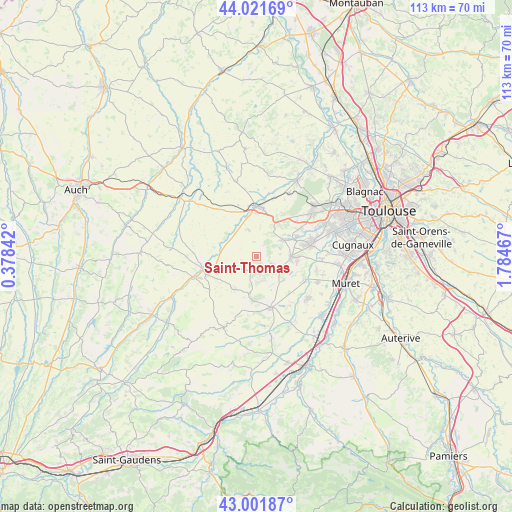
Saint-Thomas GPS coordinates[2]
43° 30' 50.148" North, 1° 4' 53.58" East
| Map corner | latitude | longitude |
|---|---|---|
| Upper-left | 44.02169°, | 0.37842° |
| Center: | 43.51393°, | 1.08155° |
| Lower-right: | 43.00187°, | 1.78467° |
| Map W x H: | 113.4×113.4 km | = 70.5×70.5mi |
| max Lat: | 51.07786° ⇑92.9% North |
| Saint-Thomas: | 43.51393° |
| min Lat: | ⇓7.1% South 41.3874° |
| min Long | Saint-Thomas | max Long |
| -5.08615° | 1.08155° | 9.52242° |
| W 32%⇐ | ⇒68% E |
Elevation
Elevation of Saint-Thomas is 323 m = 1060 ft, and this is 129.3 m = 424 ft above average elevation for this country.
| Max E: |
2333 m = 7654 ft | 16.9% |
| Saint-Thomas | 323 m 1060 ft | |
| Avg. | 193.7 m = 635 ft | |
Min E: |
-1 m = -3 ft | 83.1% |
See also: France elevation on elevation.city.
Geographical zone
Saint-Thomas is located in North temperate zone (between Tropic of Cancer and the Arctic Circle). Distance of this Northern Tropic circle is 2232.4 km =1387.1 mi to South.| Distance of | km | miles | from Saint-Thomas |
|---|---|---|---|
| North Pole | 5168.8 | 3211.7 | to North |
| Arctic Circle | 2562.9 | 1592.5 | to North |
| Tropic Cancer | 2232.4 | 1387.1 | to South |
| Equator | 4838.3 | 3006.4 | to South |


Nearby cities:
15 places around Saint-Thomas: (largest is in red/bold)
• Auradé
6.1 km =3.8 mi,  341°
341°
• Bonrepos-sur-Aussonnelle
6.4 km =4 mi,  56°
56°
• Endoufielle
6.6 km =4.1 mi,  307°
307°
• Fonsorbes
12.2 km =7.6 mi,  78°
78°
• Fontenilles
9.8 km =6.1 mi, 63°
• L’Isle-Jourdain
10.9 km =6.8 mi,  0°
0°
• Monferran-Savès
12.4 km =7.7 mi,  318°
318°
• Poucharramet
13.1 km =8.1 mi,  145°
145°
• Pujaudran
10 km =6.2 mi,  33°
33°
• Rieumes
11.8 km =7.3 mi,  165°
165°
• Saiguède
5.3 km =3.3 mi,  71°
71°
• Saint-Clar-de-Rivière
12.2 km =7.6 mi,  116°
116°
• Saint-Lys
7.6 km =4.7 mi,  92°
92°
• Sainte-Foy-de-Peyrolières
5.6 km =3.5 mi,  114°
114°
• Samatan
12.5 km =7.8 mi,  259°
259°
Sources, notices
• [Note1] Compared only with cities in France existing in our database
• [Src1] Map data: © OpenStreetMap contributors (CC-BY-SA)
• [Src2] Other city data from geonames.org with taken over terms of usage.
• [Src3] Geographical zone / Annual Mean Temperature by Robert A. Rohde @ Wikipedia
