Samatan geodata
Samatan (Occitanie) is a populated place; located in France in Europe/Paris (GMT+2) time zone. With population of 2,059 people, there are 4664 cities with bigger population in this country. Compared to other cities in France, 93.1% of cities are located further ↑North; 69.4% of cities are located further →East and 60.7% of cities have lower elevation than Samatan. Note1


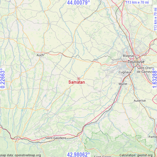
Samatan GPS coordinates[2]
43° 29' 34.296" North, 0° 55' 47.136" East
| Map corner | latitude | longitude |
|---|---|---|
| Upper-left | 44.00079°, | 0.22663° |
| Center: | 43.49286°, | 0.92976° |
| Lower-right: | 42.98062°, | 1.63288° |
| Map W x H: | 113.4×113.4 km | = 70.5×70.5mi |
| max Lat: | 51.07786° ⇑93.1% North |
| Samatan: | 43.49286° |
| min Lat: | ⇓6.9% South 41.3874° |
| min Long | Samatan | max Long |
| -5.08615° | 0.92976° | 9.52242° |
| W 30.6%⇐ | ⇒69.4% E |
Elevation
Elevation of Samatan is 173 m = 568 ft, and this is 20.7 m = 68 ft below average elevation for this country.
| Max E: |
2333 m = 7654 ft | 39.3% |
| Avg. | 193.7 m = 635 ft | |
| Samatan | 173 m = 568 ft | |
Min E: |
-1 m = -3 ft | 60.7% |
See also: France elevation on elevation.city.
Geographical zone
Samatan is located in North temperate zone (between Tropic of Cancer and the Arctic Circle). Distance of this Northern Tropic circle is 2230 km =1385.7 mi to South.| Distance of | km | miles | from Samatan |
|---|---|---|---|
| North Pole | 5171.1 | 3213.2 | to North |
| Arctic Circle | 2565.2 | 1593.9 | to North |
| Tropic Cancer | 2230 | 1385.7 | to South |
| Equator | 4836 | 3005 | to South |


Nearby cities:
15 places around Samatan: (largest is in red/bold)
• Auradé
13.1 km =8.1 mi,  51°
51°
• Bonrepos-sur-Aussonnelle
18.6 km =11.6 mi,  71°
71°
• Endoufielle
9.5 km =5.9 mi, 47°
• Escornebœuf
17.6 km =10.9 mi,  352°
352°
• Gimont
15.4 km =9.6 mi,  343°
343°
• Lombez
2.5 km =1.6 mi,  217°
217°
• L’Isle-Jourdain
18.1 km =11.2 mi,  42°
42°
• L’Isle-en-Dodon
14.3 km =8.9 mi,  212°
212°
• Monferran-Savès
12.4 km =7.7 mi,  19°
19°
• Rieumes
17.6 km =10.9 mi,  120°
120°
• Saiguède
17.7 km =11 mi,  77°
77°
• Saint-Thomas
12.5 km =7.8 mi, 79°
• Sainte-Foy-de-Peyrolières
17.3 km =10.7 mi,  90°
90°
• Saramon
13.8 km =8.6 mi,  284°
284°
• Simorre
16.4 km =10.2 mi,  253°
253°
Sources, notices
• [Note1] Compared only with cities in France existing in our database
• [Src1] Map data: © OpenStreetMap contributors (CC-BY-SA)
• [Src2] Other city data from geonames.org with taken over terms of usage.
• [Src3] Geographical zone / Annual Mean Temperature by Robert A. Rohde @ Wikipedia
