Sainte-Foy-de-Peyrolières geodata
Sainte-Foy-de-Peyrolières (Occitanie) is a populated place; located in France in Europe/Paris (GMT+2) time zone. With population of 1,615 people, there are 5780 cities with bigger population in this country. Compared to other cities in France, 93.1% of cities are located further ↑North; 67.4% of cities are located further →East and 77.5% of cities have lower elevation than Sainte-Foy-de-Peyrolières. Note1
Administrative division(s):
- Level 1: Occitanie
- Level 2: Haute-Garonne
- Level 3: Arrondissement de Muret
- Level 4: Sainte-Foy-de-Peyrolières
Current local time in Sainte-Foy-de-Peyrolières:
05:52 AM, WednesdayDifference from your time zone: hours


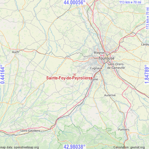
Sainte-Foy-de-Peyrolières GPS coordinates[2]
43° 29' 33.432" North, 1° 8' 41.172" East
| Map corner | latitude | longitude |
|---|---|---|
| Upper-left | 44.00056°, | 0.44164° |
| Center: | 43.49262°, | 1.14477° |
| Lower-right: | 42.98038°, | 1.84789° |
| Map W x H: | 113.4×113.4 km | = 70.5×70.5mi |
| max Lat: | 51.07786° ⇑93.1% North |
| Sainte-Foy-de-Peyrolières: | 43.49262° |
| min Lat: | ⇓6.9% South 41.3874° |
| min Long | Sainte-Foy-de-P | max Long |
| -5.08615° | 1.14477° | 9.52242° |
| W 32.6%⇐ | ⇒67.4% E |
Elevation
Elevation of Sainte-Foy-de-Peyrolières is 268 m = 879 ft, and this is 74.3 m = 244 ft above average elevation for this country.
| Max E: |
2333 m = 7654 ft | 22.5% |
| Sainte-Foy-de-Peyrolières | 268 m 879 ft | |
| Avg. | 193.7 m = 635 ft | |
Min E: |
-1 m = -3 ft | 77.5% |
See also: France elevation on elevation.city.
Geographical zone
Sainte-Foy-de-Peyrolières is located in North temperate zone (between Tropic of Cancer and the Arctic Circle). Distance of this Northern Tropic circle is 2230 km =1385.7 mi to South.| Distance of | km | miles | from Sainte-Foy-de-Peyrolières |
|---|---|---|---|
| North Pole | 5171.1 | 3213.2 | to North |
| Arctic Circle | 2565.2 | 1593.9 | to North |
| Tropic Cancer | 2230 | 1385.7 | to South |
| Equator | 4835.9 | 3004.9 | to South |


Nearby cities:
15 places around Sainte-Foy-de-Peyrolières: (largest is in red/bold)
• Auradé
10.8 km =6.7 mi,  319°
319°
• Bonrepos-sur-Aussonnelle
5.9 km =3.7 mi,  2°
2°
• Endoufielle
12.1 km =7.5 mi,  301°
301°
• Fonsorbes
8.3 km =5.2 mi,  55°
55°
• Fontenilles
7.7 km =4.8 mi,  29°
29°
• Labastidette
8.9 km =5.5 mi,  114°
114°
• Lamasquère
8.3 km =5.2 mi,  97°
97°
• Lherm
9.3 km =5.8 mi,  137°
137°
• Poucharramet
8.7 km =5.4 mi,  164°
164°
• Pujaudran
10.8 km =6.7 mi, 2°
• Rieumes
9.3 km =5.8 mi,  193°
193°
• Saiguède
4 km =2.5 mi,  359°
359°
• Saint-Clar-de-Rivière
6.6 km =4.1 mi,  118°
118°
• Saint-Lys
3.2 km =2 mi,  50°
50°
• Saint-Thomas
5.6 km =3.5 mi,  294°
294°
Sources, notices
• [Note1] Compared only with cities in France existing in our database
• [Src1] Map data: © OpenStreetMap contributors (CC-BY-SA)
• [Src2] Other city data from geonames.org with taken over terms of usage.
• [Src3] Geographical zone / Annual Mean Temperature by Robert A. Rohde @ Wikipedia
