Saujon geodata
Saujon (Nouvelle-Aquitaine) is a populated place; located in France in Europe/Paris (GMT+2) time zone. With population of 5,803 people, there are 1699 cities with bigger population in this country. Compared to other cities in France, 71.3% of cities are located further ↑North; 87.5% of cities are located further →East and 99% of cities have higher elevation than Saujon. Note1
Administrative division(s):
- Level 1: Nouvelle-Aquitaine
- Level 2: Charente-Maritime
- Level 3: Arrondissement de Saintes
- Level 4: Saujon


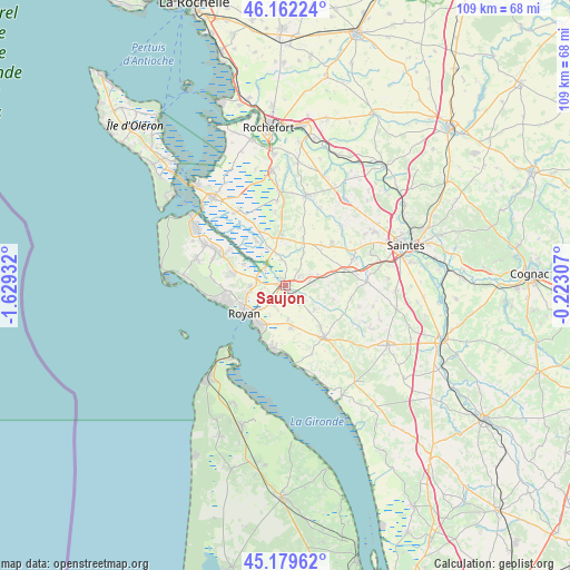
Saujon GPS coordinates[2]
45° 40' 23.124" North, 0° 55' 34.32" West
| Map corner | latitude | longitude |
|---|---|---|
| Upper-left | 46.16224°, | -1.62932° |
| Center: | 45.67309°, | -0.9262° |
| Lower-right: | 45.17962°, | -0.22307° |
| Map W x H: | 109.3×109.3 km | = 67.9×67.9mi |
| max Lat: | 51.07786° ⇑71.3% North |
| Saujon: | 45.67309° |
| min Lat: | ⇓28.7% South 41.3874° |
| min Long | Saujon | max Long |
| -5.08615° | -0.9262° | 9.52242° |
| W 12.5%⇐ | ⇒87.5% E |
Elevation
Elevation of Saujon is 6 m = 20 ft, and this is 187.7 m = 616 ft below average elevation for this country.
| Max E: |
2333 m = 7654 ft | 99% |
| Avg. | 193.7 m = 635 ft | |
| Saujon | 6 m = 20 ft | |
Min E: |
-1 m = -3 ft | 1% |
See also: France elevation on elevation.city.
Geographical zone
Saujon is located in North temperate zone (between Tropic of Cancer and the Arctic Circle). Distance of this North polar circle is 2322.8 km =1443.3 mi to North.| Distance of | km | miles | from Saujon |
|---|---|---|---|
| North Pole | 4928.7 | 3062.6 | to North |
| Arctic Circle | 2322.8 | 1443.3 | to North |
| Tropic Cancer | 2472.5 | 1536.3 | to South |
| Equator | 5078.4 | 3155.6 | to South |


Nearby cities:
15 places around Saujon: (largest is in red/bold)
• Breuillet
10 km =6.2 mi,  281°
281°
• Corme-Écluse
7.2 km =4.5 mi,  131°
131°
• Grézac
10.2 km =6.3 mi,  139°
139°
• Le Chay
4.5 km =2.8 mi,  147°
147°
• Le Gua
6.1 km =3.8 mi,  346°
346°
• Meursac
9.6 km =6 mi,  106°
106°
• Mornac-sur-Seudre
8.9 km =5.5 mi,  296°
296°
• Médis
4.4 km =2.7 mi,  220°
220°
• Nieulle-sur-Seudre
10.3 km =6.4 mi,  326°
326°
• Royan
9.3 km =5.8 mi,  237°
237°
• Sablonceaux
5 km =3.1 mi,  36°
36°
• Saint-Georges-de-Didonne
9.9 km =6.2 mi, 218°
• Saint-Romain-de-Benet
6.4 km =4 mi,  71°
71°
• Saint-Sulpice-de-Royan
6.7 km =4.2 mi,  267°
267°
• Semussac
8.2 km =5.1 mi,  174°
174°
Sources, notices
• [Note1] Compared only with cities in France existing in our database
• [Src1] Map data: © OpenStreetMap contributors (CC-BY-SA)
• [Src2] Other city data from geonames.org with taken over terms of usage.
• [Src3] Geographical zone / Annual Mean Temperature by Robert A. Rohde @ Wikipedia
