Novalaise geodata
Novalaise (Auvergne-Rhône-Alpes) is a populated place; located in France in Europe/Paris (GMT+2) time zone. With population of 1,554 people, there are 5996 cities with bigger population in this country. Compared to other cities in France, 72.7% of cities are located further ↑North; 84.9% of cities are located further ←West and 92.3% of cities have lower elevation than Novalaise. Note1
Administrative division(s):
- Level 1: Auvergne-Rhône-Alpes
- Level 2: Savoie
- Level 3: Arrondissement de Chambéry
- Level 4: Novalaise


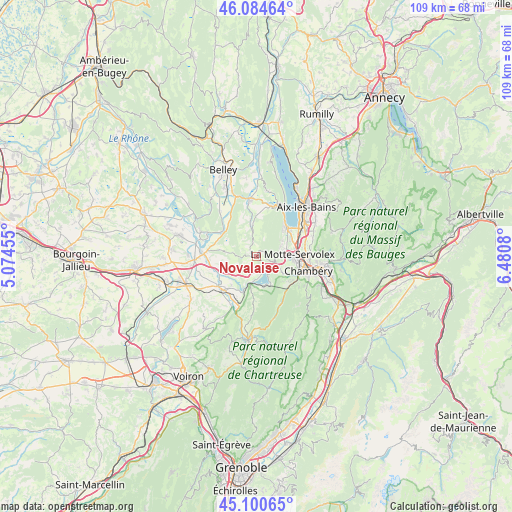
Novalaise GPS coordinates[2]
45° 35' 41.28" North, 5° 46' 39.612" East
| Map corner | latitude | longitude |
|---|---|---|
| Upper-left | 46.08464°, | 5.07455° |
| Center: | 45.5948°, | 5.77767° |
| Lower-right: | 45.10065°, | 6.4808° |
| Map W x H: | 109.4×109.4 km | = 68×68mi |
| max Lat: | 51.07786° ⇑72.7% North |
| Novalaise: | 45.5948° |
| min Lat: | ⇓27.3% South 41.3874° |
| min Long | Novalaise | max Long |
| -5.08615° | 5.77767° | 9.52242° |
| W 84.9%⇐ | ⇒15.1% E |
Elevation
Elevation of Novalaise is 484 m = 1588 ft, and this is 290.3 m = 952 ft above average elevation for this country.
| Max E: |
2333 m = 7654 ft | 7.7% |
| Novalaise | 484 m 1588 ft | |
| Avg. | 193.7 m = 635 ft | |
Min E: |
-1 m = -3 ft | 92.3% |
See also: France elevation on elevation.city.
Geographical zone
Novalaise is located in North temperate zone (between Tropic of Cancer and the Arctic Circle). Distance of this North polar circle is 2331.5 km =1448.7 mi to North.| Distance of | km | miles | from Novalaise |
|---|---|---|---|
| North Pole | 4937.4 | 3068 | to North |
| Arctic Circle | 2331.5 | 1448.7 | to North |
| Tropic Cancer | 2463.7 | 1530.9 | to South |
| Equator | 5069.7 | 3150.2 | to South |


Nearby cities:
15 places around Novalaise: (largest is in red/bold)
• Attignat-Oncin
9.6 km =6 mi,  180°
180°
• Cognin
9.7 km =6 mi,  113°
113°
• Domessin
7.7 km =4.8 mi,  227°
227°
• La Bridoire
8.3 km =5.2 mi,  200°
200°
• La Motte-Servolex
7 km =4.3 mi,  87°
87°
• Le Bourget-du-Lac
8.9 km =5.5 mi,  42°
42°
• Le Pont-de-Beauvoisin
10.4 km =6.5 mi, 231°
• Romagnieu
11 km =6.8 mi,  255°
255°
• Saint-Béron
10.9 km =6.8 mi, 200°
• Saint-Genix-sur-Guiers
11.1 km =6.9 mi,  272°
272°
• Saint-Sulpice
6.1 km =3.8 mi,  119°
119°
• Sonnaz
11 km =6.8 mi,  76°
76°
• Vimines
8.7 km =5.4 mi,  128°
128°
• Viviers-du-Lac
11.3 km =7 mi,  57°
57°
• Voglans
9 km =5.6 mi,  72°
72°
Sources, notices
• [Note1] Compared only with cities in France existing in our database
• [Src1] Map data: © OpenStreetMap contributors (CC-BY-SA)
• [Src2] Other city data from geonames.org with taken over terms of usage.
• [Src3] Geographical zone / Annual Mean Temperature by Robert A. Rohde @ Wikipedia
