Saint-Sorlin-de-Morestel geodata
Saint-Sorlin-de-Morestel (Auvergne-Rhône-Alpes) is a populated place; located in France in Europe/Paris (GMT+2) time zone. With population of 556 people, there are 14098 cities with bigger population in this country. Compared to other cities in France, 71.9% of cities are located further ↑North; 82.7% of cities are located further ←West and 80% of cities have lower elevation than Saint-Sorlin-de-Morestel. Note1
Administrative division(s):
- Level 1: Auvergne-Rhône-Alpes
- Level 2: Département de l'Isère
- Level 3: Arrondissement de La Tour-du-Pin
- Level 4: Saint-Sorlin-de-Morestel
Current local time in Saint-Sorlin-de-Morestel:
10:00 AM, SaturdayDifference from your time zone: hours


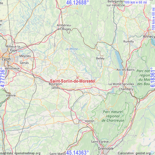
Saint-Sorlin-de-Morestel GPS coordinates[2]
45° 38' 14.676" North, 5° 28' 49.764" East
| Map corner | latitude | longitude |
|---|---|---|
| Upper-left | 46.12688°, | 4.77736° |
| Center: | 45.63741°, | 5.48049° |
| Lower-right: | 45.14363°, | 6.18361° |
| Map W x H: | 109.3×109.3 km | = 67.9×67.9mi |
| max Lat: | 51.07786° ⇑71.9% North |
| Saint-Sorlin-de-Morestel: | 45.63741° |
| min Lat: | ⇓28.1% South 41.3874° |
| min Long | Saint-Sorlin-de | max Long |
| -5.08615° | 5.48049° | 9.52242° |
| W 82.7%⇐ | ⇒17.3% E |
Elevation
Elevation of Saint-Sorlin-de-Morestel is 290 m = 951 ft, and this is 96.3 m = 316 ft above average elevation for this country.
| Max E: |
2333 m = 7654 ft | 20% |
| Saint-Sorlin-de-Morestel | 290 m 951 ft | |
| Avg. | 193.7 m = 635 ft | |
Min E: |
-1 m = -3 ft | 80% |
See also: France elevation on elevation.city.
Geographical zone
Saint-Sorlin-de-Morestel is located in North temperate zone (between Tropic of Cancer and the Arctic Circle). Distance of this North polar circle is 2326.8 km =1445.8 mi to North.| Distance of | km | miles | from Saint-Sorlin-de-Morestel |
|---|---|---|---|
| North Pole | 4932.7 | 3065 | to North |
| Arctic Circle | 2326.8 | 1445.8 | to North |
| Tropic Cancer | 2468.5 | 1533.9 | to South |
| Equator | 5074.4 | 3153.1 | to South |


Nearby cities:
15 places around Saint-Sorlin-de-Morestel: (largest is in red/bold)
• Brangues
7.4 km =4.6 mi,  32°
32°
• Corbelin
5.9 km =3.7 mi,  124°
124°
• Curtin
1 km =0.6 mi,  46°
46°
• Dolomieu
3.6 km =2.2 mi,  173°
173°
• Faverges-de-la-Tour
6.1 km =3.8 mi,  148°
148°
• La Chapelle-de-la-Tour
6 km =3.7 mi,  192°
192°
• Le Bouchage
5 km =3.1 mi,  38°
38°
• Les Avenières
6.3 km =3.9 mi,  91°
91°
• Morestel
4.8 km =3 mi,  345°
345°
• Passins
6.9 km =4.3 mi,  325°
325°
• Saint-Clair-de-la-Tour
7.1 km =4.4 mi,  181°
181°
• Saint-Victor-de-Morestel
7.2 km =4.5 mi,  12°
12°
• Sermérieu
6.5 km =4 mi,  303°
303°
• Thuellin
2.2 km =1.4 mi,  83°
83°
• Vignieu
4.2 km =2.6 mi,  264°
264°
Sources, notices
• [Note1] Compared only with cities in France existing in our database
• [Src1] Map data: © OpenStreetMap contributors (CC-BY-SA)
• [Src2] Other city data from geonames.org with taken over terms of usage.
• [Src3] Geographical zone / Annual Mean Temperature by Robert A. Rohde @ Wikipedia
