Saint-Sauveur-en-Rue geodata
Saint-Sauveur-en-Rue (Auvergne-Rhône-Alpes) is a populated place; located in France in Europe/Paris (GMT+2) time zone. With population of 1,197 people, there are 7552 cities with bigger population in this country. Compared to other cities in France, 76.7% of cities are located further ↑North; 72.1% of cities are located further ←West and 97.3% of cities have lower elevation than Saint-Sauveur-en-Rue. Note1
Administrative division(s):
- Level 1: Auvergne-Rhône-Alpes
- Level 2: Département de la Loire
- Level 3: Arrondissement de Saint-Étienne
- Level 4: Saint-Sauveur-en-Rue


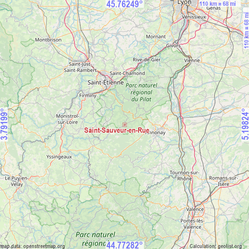
Saint-Sauveur-en-Rue GPS coordinates[2]
45° 16' 11.316" North, 4° 29' 42.432" East
| Map corner | latitude | longitude |
|---|---|---|
| Upper-left | 45.76249°, | 3.79199° |
| Center: | 45.26981°, | 4.49512° |
| Lower-right: | 44.77282°, | 5.19824° |
| Map W x H: | 110×110 km | = 68.4×68.4mi |
| max Lat: | 51.07786° ⇑76.7% North |
| Saint-Sauveur-en-Rue: | 45.26981° |
| min Lat: | ⇓23.3% South 41.3874° |
| min Long | Saint-Sauveur-e | max Long |
| -5.08615° | 4.49512° | 9.52242° |
| W 72.1%⇐ | ⇒27.9% E |
Elevation
Elevation of Saint-Sauveur-en-Rue is 753 m = 2470 ft, and this is 559.3 m = 1835 ft above average elevation for this country.
| Max E: |
2333 m = 7654 ft | 2.7% |
| Saint-Sauveur-en-Rue | 753 m 2470 ft | |
| Avg. | 193.7 m = 635 ft | |
Min E: |
-1 m = -3 ft | 97.3% |
See also: France elevation on elevation.city.
Geographical zone
Saint-Sauveur-en-Rue is located in North temperate zone (between Tropic of Cancer and the Arctic Circle). Distance of this North polar circle is 2367.6 km =1471.2 mi to North.| Distance of | km | miles | from Saint-Sauveur-en-Rue |
|---|---|---|---|
| North Pole | 4973.5 | 3090.4 | to North |
| Arctic Circle | 2367.6 | 1471.2 | to North |
| Tropic Cancer | 2427.6 | 1508.4 | to South |
| Equator | 5033.5 | 3127.7 | to South |


Nearby cities:
15 places around Saint-Sauveur-en-Rue: (largest is in red/bold)
• Boulieu-lès-Annonay
13.4 km =8.3 mi,  89°
89°
• Bourg-Argental
6.6 km =4.1 mi,  60°
60°
• Dunières
13.2 km =8.2 mi,  242°
242°
• Jonzieux
11.5 km =7.1 mi,  294°
294°
• Marlhes
7.9 km =4.9 mi,  280°
280°
• Planfoy
13.3 km =8.3 mi,  341°
341°
• Riotord
8.4 km =5.2 mi, 239°
• Roiffieux
13.4 km =8.3 mi,  111°
111°
• Saint-Genest-Malifaux
10 km =6.2 mi,  322°
322°
• Saint-Julien-Molin-Molette
11.1 km =6.9 mi, 58°
• Saint-Marcel-lès-Annonay
10.4 km =6.5 mi,  79°
79°
• Saint-Romain-Lachalm
12.6 km =7.8 mi,  268°
268°
• Vanosc
6.7 km =4.2 mi,  139°
139°
• Villevocance
8.8 km =5.5 mi,  124°
124°
• Vocance
8.8 km =5.5 mi,  149°
149°
Sources, notices
• [Note1] Compared only with cities in France existing in our database
• [Src1] Map data: © OpenStreetMap contributors (CC-BY-SA)
• [Src2] Other city data from geonames.org with taken over terms of usage.
• [Src3] Geographical zone / Annual Mean Temperature by Robert A. Rohde @ Wikipedia
