Planfoy geodata
Planfoy (Auvergne-Rhône-Alpes) is a populated place; located in France in Europe/Paris (GMT+2) time zone. With population of 870 people, there are 9896 cities with bigger population in this country. Compared to other cities in France, 75.5% of cities are located further ↑North; 71.7% of cities are located further ←West and 98.6% of cities have lower elevation than Planfoy. Note1
Administrative division(s):
- Level 1: Auvergne-Rhône-Alpes
- Level 2: Département de la Loire
- Level 3: Arrondissement de Saint-Étienne
- Level 4: Planfoy


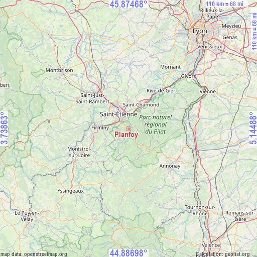
Planfoy GPS coordinates[2]
45° 22' 58.764" North, 4° 26' 30.3" East
| Map corner | latitude | longitude |
|---|---|---|
| Upper-left | 45.87468°, | 3.73863° |
| Center: | 45.38299°, | 4.44175° |
| Lower-right: | 44.88698°, | 5.14488° |
| Map W x H: | 109.8×109.8 km | = 68.2×68.2mi |
| max Lat: | 51.07786° ⇑75.5% North |
| Planfoy: | 45.38299° |
| min Lat: | ⇓24.5% South 41.3874° |
| min Long | Planfoy | max Long |
| -5.08615° | 4.44175° | 9.52242° |
| W 71.7%⇐ | ⇒28.3% E |
Elevation
Elevation of Planfoy is 898 m = 2946 ft, and this is 704.3 m = 2311 ft above average elevation for this country.
| Max E: |
2333 m = 7654 ft | 1.4% |
| Planfoy | 898 m 2946 ft | |
| Avg. | 193.7 m = 635 ft | |
Min E: |
-1 m = -3 ft | 98.6% |
See also: France elevation on elevation.city.
Geographical zone
Planfoy is located in North temperate zone (between Tropic of Cancer and the Arctic Circle). Distance of this North polar circle is 2355.1 km =1463.4 mi to North.| Distance of | km | miles | from Planfoy |
|---|---|---|---|
| North Pole | 4960.9 | 3082.6 | to North |
| Arctic Circle | 2355.1 | 1463.4 | to North |
| Tropic Cancer | 2440.2 | 1516.3 | to South |
| Equator | 5046.1 | 3135.5 | to South |


Nearby cities:
15 places around Planfoy: (largest is in red/bold)
• Jonzieux
9.9 km =6.2 mi,  219°
219°
• La Ricamarie
6.2 km =3.9 mi,  293°
293°
• La Talaudière
10.4 km =6.5 mi,  353°
353°
• La Valla-en-Gier
7.2 km =4.5 mi,  55°
55°
• Le Chambon-Feugerolles
9.4 km =5.8 mi,  275°
275°
• Roche-la-Molière
10.3 km =6.4 mi,  300°
300°
• Saint-Chamond
11.7 km =7.3 mi,  28°
28°
• Saint-Genest-Lerpt
10.4 km =6.5 mi,  310°
310°
• Saint-Genest-Malifaux
5.1 km =3.2 mi,  202°
202°
• Saint-Jean-Bonnefonds
8.1 km =5 mi,  0°
0°
• Saint-Just-Malmont
11.2 km =7 mi,  244°
244°
• Saint-Priest-en-Jarez
11.3 km =7 mi,  333°
333°
• Saint-Romain-les-Atheux
5.3 km =3.3 mi,  249°
249°
• Saint-Étienne
7 km =4.3 mi,  324°
324°
• Villars
11.6 km =7.2 mi, 324°
Sources, notices
• [Note1] Compared only with cities in France existing in our database
• [Src1] Map data: © OpenStreetMap contributors (CC-BY-SA)
• [Src2] Other city data from geonames.org with taken over terms of usage.
• [Src3] Geographical zone / Annual Mean Temperature by Robert A. Rohde @ Wikipedia
