Saint-Romans geodata
Saint-Romans (Auvergne-Rhône-Alpes) is a populated place; located in France in Europe/Paris (GMT+2) time zone. With population of 1,547 people, there are 6025 cities with bigger population in this country. Compared to other cities in France, 78.4% of cities are located further ↑North; 80.8% of cities are located further ←West and 73.7% of cities have lower elevation than Saint-Romans. Note1
Administrative division(s):
- Level 1: Auvergne-Rhône-Alpes
- Level 2: Département de l'Isère
- Level 3: Arrondissement de Grenoble
- Level 4: Saint-Romans


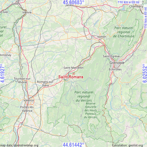
Saint-Romans GPS coordinates[2]
45° 6' 46.008" North, 5° 19' 20.604" East
| Map corner | latitude | longitude |
|---|---|---|
| Upper-left | 45.60683°, | 4.61927° |
| Center: | 45.11278°, | 5.32239° |
| Lower-right: | 44.61442°, | 6.02552° |
| Map W x H: | 110.3×110.3 km | = 68.5×68.5mi |
| max Lat: | 51.07786° ⇑78.4% North |
| Saint-Romans: | 45.11278° |
| min Lat: | ⇓21.6% South 41.3874° |
| min Long | Saint-Romans | max Long |
| -5.08615° | 5.32239° | 9.52242° |
| W 80.8%⇐ | ⇒19.2% E |
Elevation
Elevation of Saint-Romans is 240 m = 787 ft, and this is 46.3 m = 152 ft above average elevation for this country.
| Max E: |
2333 m = 7654 ft | 26.3% |
| Saint-Romans | 240 m 787 ft | |
| Avg. | 193.7 m = 635 ft | |
Min E: |
-1 m = -3 ft | 73.7% |
See also: France elevation on elevation.city.
Geographical zone
Saint-Romans is located in North temperate zone (between Tropic of Cancer and the Arctic Circle). Distance of this North polar circle is 2385.1 km =1482 mi to North.| Distance of | km | miles | from Saint-Romans |
|---|---|---|---|
| North Pole | 4991 | 3101.3 | to North |
| Arctic Circle | 2385.1 | 1482 | to North |
| Tropic Cancer | 2410.2 | 1497.6 | to South |
| Equator | 5016.1 | 3116.9 | to South |


Nearby cities:
15 places around Saint-Romans: (largest is in red/bold)
• Chatte
4.6 km =2.9 mi,  316°
316°
• Chevrières
8.7 km =5.4 mi,  342°
342°
• Izeron
5.3 km =3.3 mi,  48°
48°
• La Sône
3.5 km =2.2 mi,  266°
266°
• Pont-en-Royans
5.8 km =3.6 mi,  165°
165°
• Saint-Bonnet-de-Chavagne
7.3 km =4.5 mi,  281°
281°
• Saint-Hilaire-du-Rosier
5.9 km =3.7 mi,  255°
255°
• Saint-Just-de-Claix
5.2 km =3.2 mi,  216°
216°
• Saint-Marcellin
4.1 km =2.5 mi,  353°
353°
• Saint-Nazaire-en-Royans
8.2 km =5.1 mi, 224°
• Saint-Sauveur
5.1 km =3.2 mi,  27°
27°
• Saint-Thomas-en-Royans
7.4 km =4.6 mi,  197°
197°
• Saint-Vérand
6.8 km =4.2 mi,  6°
6°
• Sainte-Eulalie-en-Royans
7.3 km =4.5 mi,  162°
162°
• Têche
8.8 km =5.5 mi, 29°
Sources, notices
• [Note1] Compared only with cities in France existing in our database
• [Src1] Map data: © OpenStreetMap contributors (CC-BY-SA)
• [Src2] Other city data from geonames.org with taken over terms of usage.
• [Src3] Geographical zone / Annual Mean Temperature by Robert A. Rohde @ Wikipedia
