Saint-Marcellin geodata
Saint-Marcellin (Auvergne-Rhône-Alpes) is a populated place; located in France in Europe/Paris (GMT+2) time zone. With population of 7,592 people, there are 1278 cities with bigger population in this country. Compared to other cities in France, 77.9% of cities are located further ↑North; 80.7% of cities are located further ←West and 77.5% of cities have lower elevation than Saint-Marcellin. Note1
Administrative division(s):
- Level 1: Auvergne-Rhône-Alpes
- Level 2: Département de l'Isère
- Level 3: Arrondissement de Grenoble
- Level 4: Saint-Marcellin


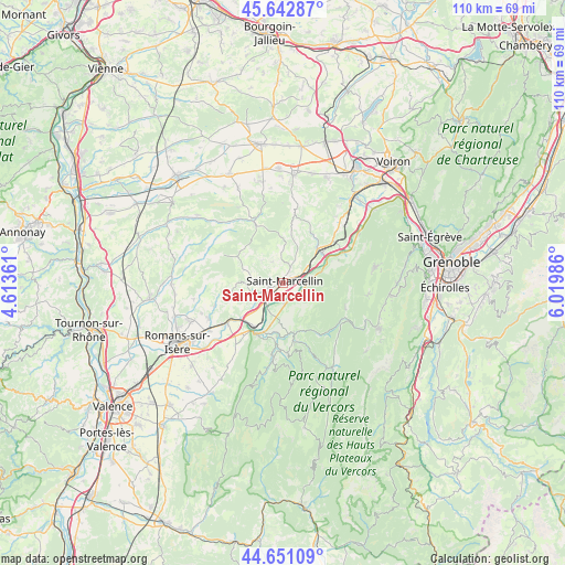
Saint-Marcellin GPS coordinates[2]
45° 8' 56.904" North, 5° 19' 0.228" East
| Map corner | latitude | longitude |
|---|---|---|
| Upper-left | 45.64287°, | 4.61361° |
| Center: | 45.14914°, | 5.31673° |
| Lower-right: | 44.65109°, | 6.01986° |
| Map W x H: | 110.3×110.3 km | = 68.5×68.5mi |
| max Lat: | 51.07786° ⇑77.9% North |
| Saint-Marcellin: | 45.14914° |
| min Lat: | ⇓22.1% South 41.3874° |
| min Long | Saint-Marcellin | max Long |
| -5.08615° | 5.31673° | 9.52242° |
| W 80.7%⇐ | ⇒19.3% E |
Elevation
Elevation of Saint-Marcellin is 268 m = 879 ft, and this is 74.3 m = 244 ft above average elevation for this country.
| Max E: |
2333 m = 7654 ft | 22.5% |
| Saint-Marcellin | 268 m 879 ft | |
| Avg. | 193.7 m = 635 ft | |
Min E: |
-1 m = -3 ft | 77.5% |
See also: France elevation on elevation.city.
Geographical zone
Saint-Marcellin is located in North temperate zone (between Tropic of Cancer and the Arctic Circle). Distance of this North polar circle is 2381.1 km =1479.5 mi to North.| Distance of | km | miles | from Saint-Marcellin |
|---|---|---|---|
| North Pole | 4986.9 | 3098.7 | to North |
| Arctic Circle | 2381.1 | 1479.5 | to North |
| Tropic Cancer | 2414.2 | 1500.1 | to South |
| Equator | 5020.1 | 3119.3 | to South |


Nearby cities:
15 places around Saint-Marcellin: (largest is in red/bold)
• Beaulieu
6.9 km =4.3 mi,  61°
61°
• Chatte
2.8 km =1.7 mi,  254°
254°
• Chevrières
4.8 km =3 mi,  332°
332°
• Cognin-les-Gorges
7.8 km =4.8 mi,  72°
72°
• Izeron
4.4 km =2.7 mi,  96°
96°
• La Sône
5.2 km =3.2 mi,  215°
215°
• Saint-Antoine-l'Abbaye
8.1 km =5 mi,  283°
283°
• Saint-Bonnet-de-Chavagne
7.2 km =4.5 mi, 248°
• Saint-Hilaire-du-Rosier
7.6 km =4.7 mi, 223°
• Saint-Just-de-Claix
8.6 km =5.3 mi,  197°
197°
• Saint-Romans
4.1 km =2.5 mi,  173°
173°
• Saint-Sauveur
2.9 km =1.8 mi,  80°
80°
• Saint-Vérand
3 km =1.9 mi,  24°
24°
• Têche
6 km =3.7 mi,  52°
52°
• Varacieux
9.4 km =5.8 mi,  9°
9°
Sources, notices
• [Note1] Compared only with cities in France existing in our database
• [Src1] Map data: © OpenStreetMap contributors (CC-BY-SA)
• [Src2] Other city data from geonames.org with taken over terms of usage.
• [Src3] Geographical zone / Annual Mean Temperature by Robert A. Rohde @ Wikipedia
