Saint-Hilaire-du-Rosier geodata
Saint-Hilaire-du-Rosier (Auvergne-Rhône-Alpes) is a populated place; located in France in Europe/Paris (GMT+2) time zone. With population of 1,908 people, there are 5014 cities with bigger population in this country. Compared to other cities in France, 78.6% of cities are located further ↑North; 80.2% of cities are located further ←West and 71.7% of cities have lower elevation than Saint-Hilaire-du-Rosier. Note1
Administrative division(s):
- Level 1: Auvergne-Rhône-Alpes
- Level 2: Département de l'Isère
- Level 3: Arrondissement de Grenoble
- Level 4: Saint-Hilaire-du-Rosier
Current local time in Saint-Hilaire-du-Rosier:
08:14 PM, SaturdayDifference from your time zone: hours


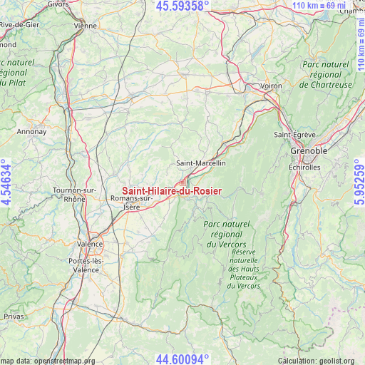
Saint-Hilaire-du-Rosier GPS coordinates[2]
45° 5' 57.912" North, 5° 14' 58.056" East
| Map corner | latitude | longitude |
|---|---|---|
| Upper-left | 45.59358°, | 4.54634° |
| Center: | 45.09942°, | 5.24946° |
| Lower-right: | 44.60094°, | 5.95259° |
| Map W x H: | 110.4×110.4 km | = 68.6×68.6mi |
| max Lat: | 51.07786° ⇑78.6% North |
| Saint-Hilaire-du-Rosier: | 45.09942° |
| min Lat: | ⇓21.4% South 41.3874° |
| min Long | Saint-Hilaire-d | max Long |
| -5.08615° | 5.24946° | 9.52242° |
| W 80.2%⇐ | ⇒19.8% E |
Elevation
Elevation of Saint-Hilaire-du-Rosier is 228 m = 748 ft, and this is 34.3 m = 113 ft above average elevation for this country.
| Max E: |
2333 m = 7654 ft | 28.3% |
| Saint-Hilaire-du-Rosier | 228 m 748 ft | |
| Avg. | 193.7 m = 635 ft | |
Min E: |
-1 m = -3 ft | 71.7% |
See also: France elevation on elevation.city.
Geographical zone
Saint-Hilaire-du-Rosier is located in North temperate zone (between Tropic of Cancer and the Arctic Circle). Distance of this North polar circle is 2386.6 km =1483 mi to North.| Distance of | km | miles | from Saint-Hilaire-du-Rosier |
|---|---|---|---|
| North Pole | 4992.5 | 3102.2 | to North |
| Arctic Circle | 2386.6 | 1483 | to North |
| Tropic Cancer | 2408.7 | 1496.7 | to South |
| Equator | 5014.6 | 3115.9 | to South |


Nearby cities:
15 places around Saint-Hilaire-du-Rosier: (largest is in red/bold)
• Chatte
5.4 km =3.4 mi,  28°
28°
• Eymeux
6.1 km =3.8 mi,  245°
245°
• Hostun
8.3 km =5.2 mi,  207°
207°
• La Sône
2.6 km =1.6 mi,  59°
59°
• Parnans
8.4 km =5.2 mi,  277°
277°
• Pont-en-Royans
8.3 km =5.2 mi,  119°
119°
• Saint-Antoine-l'Abbaye
7.9 km =4.9 mi,  341°
341°
• Saint-Bonnet-de-Chavagne
3.3 km =2.1 mi,  334°
334°
• Saint-Jean-en-Royans
9.5 km =5.9 mi,  159°
159°
• Saint-Just-de-Claix
3.7 km =2.3 mi,  135°
135°
• Saint-Lattier
3.8 km =2.4 mi, 250°
• Saint-Marcellin
7.6 km =4.7 mi,  43°
43°
• Saint-Nazaire-en-Royans
4.3 km =2.7 mi,  179°
179°
• Saint-Romans
5.9 km =3.7 mi,  75°
75°
• Saint-Thomas-en-Royans
6.6 km =4.1 mi,  147°
147°
Sources, notices
• [Note1] Compared only with cities in France existing in our database
• [Src1] Map data: © OpenStreetMap contributors (CC-BY-SA)
• [Src2] Other city data from geonames.org with taken over terms of usage.
• [Src3] Geographical zone / Annual Mean Temperature by Robert A. Rohde @ Wikipedia
