Saint-Romain geodata
Saint-Romain (Nouvelle-Aquitaine) is a populated place; located in France in Europe/Paris (GMT+2) time zone. With population of 532 people, there are 14567 cities with bigger population in this country. Compared to other cities in France, 76.5% of cities are located further ↑North; 76.7% of cities are located further →East and 65.6% of cities have higher elevation than Saint-Romain. Note1
Administrative division(s):
- Level 1: Nouvelle-Aquitaine
- Level 2: Charente
- Level 3: Arrondissement d’Angoulême
- Level 4: Saint-Romain


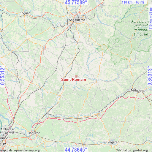
Saint-Romain GPS coordinates[2]
45° 16' 59.988" North, 0° 9' 0" East
| Map corner | latitude | longitude |
|---|---|---|
| Upper-left | 45.77589°, | -0.55312° |
| Center: | 45.28333°, | 0.15° |
| Lower-right: | 44.78645°, | 0.85313° |
| Map W x H: | 110×110 km | = 68.4×68.4mi |
| max Lat: | 51.07786° ⇑76.5% North |
| Saint-Romain: | 45.28333° |
| min Lat: | ⇓23.5% South 41.3874° |
| min Long | Saint-Romain | max Long |
| -5.08615° | 0.15° | 9.52242° |
| W 23.3%⇐ | ⇒76.7% E |
Elevation
Elevation of Saint-Romain is 88 m = 289 ft, and this is 105.7 m = 347 ft below average elevation for this country.
| Max E: |
2333 m = 7654 ft | 65.6% |
| Avg. | 193.7 m = 635 ft | |
| Saint-Romain | 88 m = 289 ft | |
Min E: |
-1 m = -3 ft | 34.4% |
See also: France elevation on elevation.city.
Geographical zone
Saint-Romain is located in North temperate zone (between Tropic of Cancer and the Arctic Circle). Distance of this North polar circle is 2366.1 km =1470.2 mi to North.| Distance of | km | miles | from Saint-Romain |
|---|---|---|---|
| North Pole | 4972 | 3089.5 | to North |
| Arctic Circle | 2366.1 | 1470.2 | to North |
| Tropic Cancer | 2429.1 | 1509.4 | to South |
| Equator | 5035 | 3128.6 | to South |


Nearby cities:
15 places around Saint-Romain: (largest is in red/bold)
• Allemans
11.7 km =7.3 mi,  90°
90°
• Brossac
16.6 km =10.3 mi,  289°
289°
• Chalais
8.8 km =5.5 mi,  262°
262°
• La Roche-Chalais
18.1 km =11.2 mi,  215°
215°
• Montmoreau-Saint-Cybard
13 km =8.1 mi,  354°
354°
• Ribérac
14.8 km =9.2 mi,  104°
104°
• Saint-Aigulin
18.7 km =11.6 mi, 221°
• Saint-Amant-de-Montmoreau
13 km =8.1 mi,  0°
0°
• Saint-Aulaye
9.4 km =5.8 mi,  188°
188°
• Saint-Martin-de-Ribérac
16.6 km =10.3 mi,  109°
109°
• Saint-Privat-des-Prés
7.6 km =4.7 mi,  136°
136°
• Saint-Séverin
8.7 km =5.4 mi,  64°
64°
• Vanxains
12.8 km =8 mi,  125°
125°
• Verteillac
18.3 km =11.4 mi,  67°
67°
• Villetoureix
16.8 km =10.4 mi, 97°
Sources, notices
• [Note1] Compared only with cities in France existing in our database
• [Src1] Map data: © OpenStreetMap contributors (CC-BY-SA)
• [Src2] Other city data from geonames.org with taken over terms of usage.
• [Src3] Geographical zone / Annual Mean Temperature by Robert A. Rohde @ Wikipedia
