Chauvigné geodata
Chauvigné (Brittany) is a populated place; located in France in Europe/Paris (GMT+2) time zone. With population of 685 people, there are 12013 cities with bigger population in this country. Compared to other cities in France, 65.9% of cities are located further ↓South; 92% of cities are located further →East and 67.4% of cities have higher elevation than Chauvigné. Note1
Administrative division(s):
- Level 1: Brittany
- Level 2: Département d'Ille-et-Vilaine
- Level 3: Arrondissement de Fougères-Vitré
- Level 4: Chauvigné


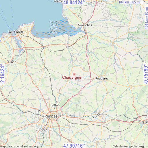
Chauvigné GPS coordinates[2]
48° 22' 34.824" North, 1° 27' 40.032" West
| Map corner | latitude | longitude |
|---|---|---|
| Upper-left | 48.84124°, | -2.16424° |
| Center: | 48.37634°, | -1.46112° |
| Lower-right: | 47.90716°, | -0.75799° |
| Map W x H: | 103.9×103.9 km | = 64.6×64.6mi |
| max Lat: | 51.07786° ⇑34.1% North |
| Chauvigné: | 48.37634° |
| min Lat: | ⇓65.9% South 41.3874° |
| min Long | Chauvigné | max Long |
| -5.08615° | -1.46112° | 9.52242° |
| W 8%⇐ | ⇒92% E |
Elevation
Elevation of Chauvigné is 84 m = 276 ft, and this is 109.7 m = 360 ft below average elevation for this country.
| Max E: |
2333 m = 7654 ft | 67.4% |
| Avg. | 193.7 m = 635 ft | |
| Chauvigné | 84 m = 276 ft | |
Min E: |
-1 m = -3 ft | 32.6% |
See also: France elevation on elevation.city.
Geographical zone
Chauvigné is located in North temperate zone (between Tropic of Cancer and the Arctic Circle). Distance of this North polar circle is 2022.2 km =1256.5 mi to North.| Distance of | km | miles | from Chauvigné |
|---|---|---|---|
| North Pole | 4628.1 | 2875.8 | to North |
| Arctic Circle | 2022.2 | 1256.5 | to North |
| Tropic Cancer | 2773 | 1723.1 | to South |
| Equator | 5378.9 | 3342.3 | to South |


Nearby cities:
15 places around Chauvigné: (largest is in red/bold)
• Antrain
9.5 km =5.9 mi,  349°
349°
• Bazouges-la-Pérouse
10 km =6.2 mi,  303°
303°
• Gahard
9.8 km =6.1 mi,  206°
206°
• La Fontenelle
10.5 km =6.5 mi,  342°
342°
• Marcillé-Raoul
10.7 km =6.6 mi,  274°
274°
• Mézières-sur-Couesnon
9.3 km =5.8 mi,  167°
167°
• Saint-Brice-en-Coglès
7.8 km =4.8 mi,  59°
59°
• Saint-Hilaire-des-Landes
8 km =5 mi,  109°
109°
• Saint-Marc-le-Blanc
4 km =2.5 mi, 108°
• Saint-Ouen-des-Alleux
6 km =3.7 mi,  154°
154°
• Saint-Rémy-du-Plain
7.9 km =4.9 mi,  262°
262°
• Saint-Étienne-en-Coglès
10.2 km =6.3 mi,  73°
73°
• Sens-de-Bretagne
7.3 km =4.5 mi,  228°
228°
• Tremblay
5.2 km =3.2 mi, 348°
• Vieux-Vy-sur-Couesnon
4.4 km =2.7 mi, 208°
Sources, notices
• [Note1] Compared only with cities in France existing in our database
• [Src1] Map data: © OpenStreetMap contributors (CC-BY-SA)
• [Src2] Other city data from geonames.org with taken over terms of usage.
• [Src3] Geographical zone / Annual Mean Temperature by Robert A. Rohde @ Wikipedia
