Antrain geodata
Antrain (Brittany) is a populated place; located in France in Europe/Paris (GMT+2) time zone. With population of 1,523 people, there are 6110 cities with bigger population in this country. Compared to other cities in France, 67.5% of cities are located further ↓South; 92.1% of cities are located further →East and 87.1% of cities have higher elevation than Antrain. Note1
Administrative division(s):
- Level 1: Brittany
- Level 2: Département d'Ille-et-Vilaine
- Level 3: Arrondissement de Fougères-Vitré
- Level 4: Val-Couesnon


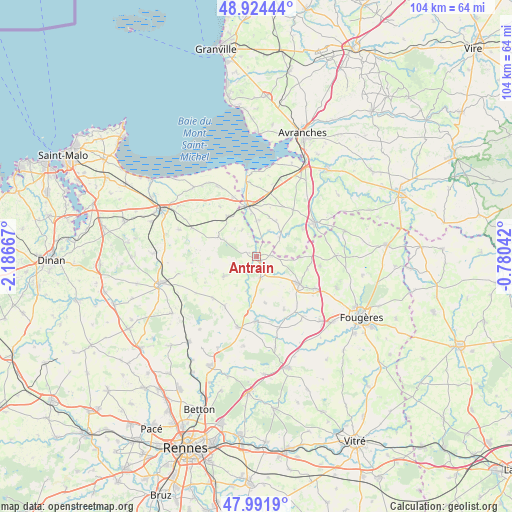
Antrain GPS coordinates[2]
48° 27' 37.116" North, 1° 29' 0.744" West
| Map corner | latitude | longitude |
|---|---|---|
| Upper-left | 48.92444°, | -2.18667° |
| Center: | 48.46031°, | -1.48354° |
| Lower-right: | 47.9919°, | -0.78042° |
| Map W x H: | 103.7×103.7 km | = 64.4×64.4mi |
| max Lat: | 51.07786° ⇑32.5% North |
| Antrain: | 48.46031° |
| min Lat: | ⇓67.5% South 41.3874° |
| min Long | Antrain | max Long |
| -5.08615° | -1.48354° | 9.52242° |
| W 7.9%⇐ | ⇒92.1% E |
Elevation
Elevation of Antrain is 37 m = 121 ft, and this is 156.7 m = 514 ft below average elevation for this country.
| Max E: |
2333 m = 7654 ft | 87.1% |
| Avg. | 193.7 m = 635 ft | |
| Antrain | 37 m = 121 ft | |
Min E: |
-1 m = -3 ft | 12.9% |
See also: France elevation on elevation.city.
Geographical zone
Antrain is located in North temperate zone (between Tropic of Cancer and the Arctic Circle). Distance of this North polar circle is 2012.9 km =1250.8 mi to North.| Distance of | km | miles | from Antrain |
|---|---|---|---|
| North Pole | 4618.8 | 2870 | to North |
| Arctic Circle | 2012.9 | 1250.8 | to North |
| Tropic Cancer | 2782.4 | 1728.9 | to South |
| Equator | 5388.3 | 3348.1 | to South |


Nearby cities:
15 places around Antrain: (largest is in red/bold)
• Argouges
7.9 km =4.9 mi,  53°
53°
• Bazouges-la-Pérouse
7.7 km =4.8 mi,  240°
240°
• Chauvigné
9.5 km =5.9 mi,  169°
169°
• Coglès
8.7 km =5.4 mi,  91°
91°
• La Fontenelle
1.6 km =1 mi,  296°
296°
• Marcillé-Raoul
12.3 km =7.6 mi,  226°
226°
• Pleine-Fougères
10.1 km =6.3 mi,  323°
323°
• Pontorson
10.5 km =6.5 mi,  350°
350°
• Sacey
5.9 km =3.7 mi,  24°
24°
• Saint-Brice-en-Coglès
10 km =6.2 mi,  122°
122°
• Saint-Marc-le-Blanc
11.9 km =7.4 mi,  152°
152°
• Saint-Rémy-du-Plain
12.1 km =7.5 mi,  210°
210°
• Sougéal
6.3 km =3.9 mi,  332°
332°
• Trans-la-Forêt
9.7 km =6 mi, 297°
• Tremblay
4.3 km =2.7 mi, 172°
Sources, notices
• [Note1] Compared only with cities in France existing in our database
• [Src1] Map data: © OpenStreetMap contributors (CC-BY-SA)
• [Src2] Other city data from geonames.org with taken over terms of usage.
• [Src3] Geographical zone / Annual Mean Temperature by Robert A. Rohde @ Wikipedia
