Loupes geodata
Loupes (Nouvelle-Aquitaine) is a populated place; located in France in Europe/Paris (GMT+2) time zone. With population of 511 people, there are 15016 cities with bigger population in this country. Compared to other cities in France, 81.3% of cities are located further ↑North; 81.9% of cities are located further →East and 62% of cities have higher elevation than Loupes. Note1
Administrative division(s):
- Level 1: Nouvelle-Aquitaine
- Level 2: Gironde
- Level 3: Arrondissement de Bordeaux
- Level 4: Loupes


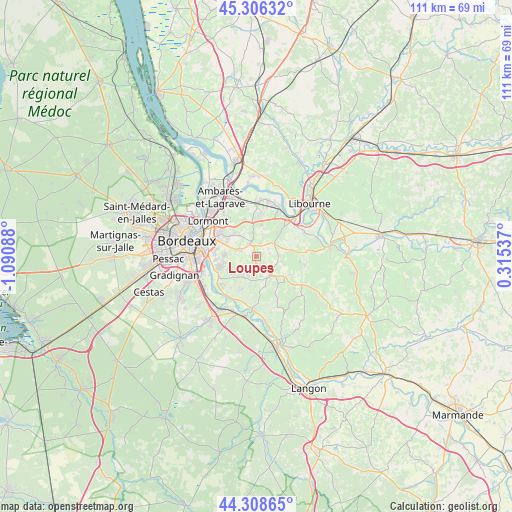
Loupes GPS coordinates[2]
44° 48' 34.704" North, 0° 23' 15.9" West
| Map corner | latitude | longitude |
|---|---|---|
| Upper-left | 45.30632°, | -1.09088° |
| Center: | 44.80964°, | -0.38775° |
| Lower-right: | 44.30865°, | 0.31537° |
| Map W x H: | 110.9×110.9 km | = 68.9×68.9mi |
| max Lat: | 51.07786° ⇑81.3% North |
| Loupes: | 44.80964° |
| min Lat: | ⇓18.7% South 41.3874° |
| min Long | Loupes | max Long |
| -5.08615° | -0.38775° | 9.52242° |
| W 18.1%⇐ | ⇒81.9% E |
Elevation
Elevation of Loupes is 97 m = 318 ft, and this is 96.7 m = 317 ft below average elevation for this country.
| Max E: |
2333 m = 7654 ft | 62% |
| Avg. | 193.7 m = 635 ft | |
| Loupes | 97 m = 318 ft | |
Min E: |
-1 m = -3 ft | 38% |
See also: France elevation on elevation.city.
Geographical zone
Loupes is located in North temperate zone (between Tropic of Cancer and the Arctic Circle). Distance of this Northern Tropic circle is 2376.4 km =1476.6 mi to South.| Distance of | km | miles | from Loupes |
|---|---|---|---|
| North Pole | 5024.7 | 3122.2 | to North |
| Arctic Circle | 2418.8 | 1503 | to North |
| Tropic Cancer | 2376.4 | 1476.6 | to South |
| Equator | 4982.4 | 3095.9 | to South |


Nearby cities:
15 places around Loupes: (largest is in red/bold)
• Baron
6.1 km =3.8 mi,  77°
77°
• Bonnetan
2.3 km =1.4 mi,  286°
286°
• Camarsac
3.1 km =1.9 mi,  37°
37°
• Carignan-de-Bordeaux
7.6 km =4.7 mi,  261°
261°
• Créon
5 km =3.1 mi,  141°
141°
• Cénac
6.6 km =4.1 mi,  239°
239°
• Fargues-Saint-Hilaire
4.9 km =3 mi, 287°
• La Sauve
7.4 km =4.6 mi,  130°
130°
• Lignan-de-Bordeaux
3.5 km =2.2 mi,  245°
245°
• Pompignac
6 km =3.7 mi,  319°
319°
• Sadirac
3.7 km =2.3 mi,  213°
213°
• Saint-Caprais-de-Bordeaux
7.7 km =4.8 mi, 206°
• Saint-Germain-du-Puch
7.2 km =4.5 mi,  51°
51°
• Sallebœuf
2.8 km =1.7 mi,  339°
339°
• Tresses
7.3 km =4.5 mi,  305°
305°
Sources, notices
• [Note1] Compared only with cities in France existing in our database
• [Src1] Map data: © OpenStreetMap contributors (CC-BY-SA)
• [Src2] Other city data from geonames.org with taken over terms of usage.
• [Src3] Geographical zone / Annual Mean Temperature by Robert A. Rohde @ Wikipedia
