Arveyres geodata
Arveyres (Nouvelle-Aquitaine) is a populated place; located in France in Europe/Paris (GMT+2) time zone. With population of 1,793 people, there are 5298 cities with bigger population in this country. Compared to other cities in France, 80.6% of cities are located further ↑North; 80.7% of cities are located further →East and 92% of cities have higher elevation than Arveyres. Note1
Administrative division(s):
- Level 1: Nouvelle-Aquitaine
- Level 2: Gironde
- Level 3: Arrondissement de Libourne
- Level 4: Arveyres


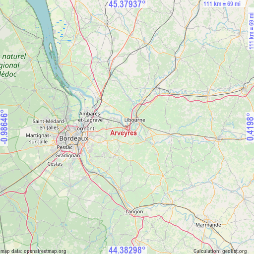
Arveyres GPS coordinates[2]
44° 52' 59.988" North, 0° 16' 59.988" West
| Map corner | latitude | longitude |
|---|---|---|
| Upper-left | 45.37937°, | -0.98646° |
| Center: | 44.88333°, | -0.28333° |
| Lower-right: | 44.38298°, | 0.4198° |
| Map W x H: | 110.8×110.8 km | = 68.8×68.8mi |
| max Lat: | 51.07786° ⇑80.6% North |
| Arveyres: | 44.88333° |
| min Lat: | ⇓19.4% South 41.3874° |
| min Long | Arveyres | max Long |
| -5.08615° | -0.28333° | 9.52242° |
| W 19.3%⇐ | ⇒80.7% E |
Elevation
Elevation of Arveyres is 25 m = 82 ft, and this is 168.7 m = 553 ft below average elevation for this country.
| Max E: |
2333 m = 7654 ft | 92% |
| Avg. | 193.7 m = 635 ft | |
| Arveyres | 25 m = 82 ft | |
Min E: |
-1 m = -3 ft | 8% |
See also: France elevation on elevation.city.
Geographical zone
Arveyres is located in North temperate zone (between Tropic of Cancer and the Arctic Circle). Distance of this Northern Tropic circle is 2384.6 km =1481.7 mi to South.| Distance of | km | miles | from Arveyres |
|---|---|---|---|
| North Pole | 5016.5 | 3117.1 | to North |
| Arctic Circle | 2410.6 | 1497.9 | to North |
| Tropic Cancer | 2384.6 | 1481.7 | to South |
| Equator | 4990.6 | 3101 | to South |


Nearby cities:
15 places around Arveyres: (largest is in red/bold)
• Baron
7.2 km =4.5 mi,  198°
198°
• Camarsac
8.5 km =5.3 mi,  227°
227°
• Fronsac
3.9 km =2.4 mi,  19°
19°
• Génissac
4.5 km =2.8 mi,  144°
144°
• Izon
7.8 km =4.8 mi,  305°
305°
• Les Billaux
8.4 km =5.2 mi,  27°
27°
• Libourne
4.7 km =2.9 mi,  41°
41°
• Moulon
6.4 km =4 mi,  125°
125°
• Nérigean
5.6 km =3.5 mi,  180°
180°
• Pomerol
8.6 km =5.3 mi,  49°
49°
• Saint-Germain-du-Puch
4.5 km =2.8 mi,  215°
215°
• Saint-Michel-de-Fronsac
6.1 km =3.8 mi,  334°
334°
• Saint-Quentin-de-Baron
7.3 km =4.5 mi, 181°
• Saint-Sulpice-de-Faleyrens
8.1 km =5 mi,  103°
103°
• Vayres
3.2 km =2 mi, 305°
Sources, notices
• [Note1] Compared only with cities in France existing in our database
• [Src1] Map data: © OpenStreetMap contributors (CC-BY-SA)
• [Src2] Other city data from geonames.org with taken over terms of usage.
• [Src3] Geographical zone / Annual Mean Temperature by Robert A. Rohde @ Wikipedia
