Saint-Pierre geodata
Saint-Pierre (Grand Est) is a populated place; located in France in Europe/Paris (GMT+2) time zone. With population of 567 people, there are 13878 cities with bigger population in this country. Compared to other cities in France, 66.1% of cities are located further ↓South; 97.7% of cities are located further ←West and 61% of cities have lower elevation than Saint-Pierre. Note1
Administrative division(s):
- Level 1: Grand Est
- Level 2: Bas-Rhin
- Level 3: Arrondissement de Sélestat-Erstein
- Level 4: Saint-Pierre


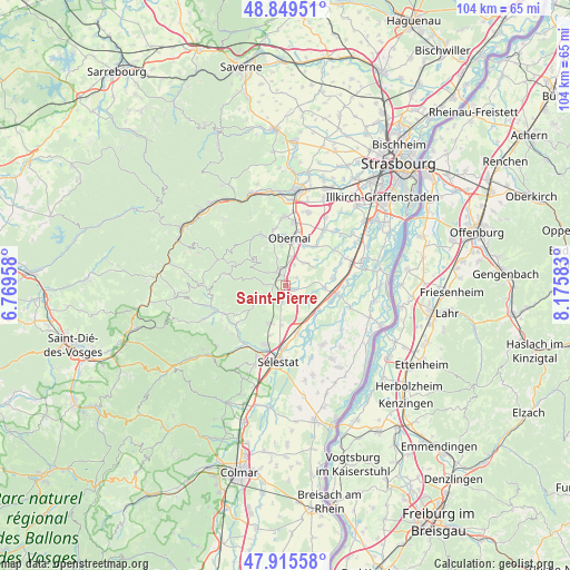
Saint-Pierre GPS coordinates[2]
48° 23' 4.884" North, 7° 28' 21.72" East
| Map corner | latitude | longitude |
|---|---|---|
| Upper-left | 48.84951°, | 6.76958° |
| Center: | 48.38469°, | 7.4727° |
| Lower-right: | 47.91558°, | 8.17583° |
| Map W x H: | 103.8×103.8 km | = 64.5×64.5mi |
| max Lat: | 51.07786° ⇑33.9% North |
| Saint-Pierre: | 48.38469° |
| min Lat: | ⇓66.1% South 41.3874° |
| min Long | Saint-Pierre | max Long |
| -5.08615° | 7.4727° | 9.52242° |
| W 97.7%⇐ | ⇒2.3% E |
Elevation
Elevation of Saint-Pierre is 175 m = 574 ft, and this is 18.7 m = 61 ft below average elevation for this country.
| Max E: |
2333 m = 7654 ft | 39% |
| Avg. | 193.7 m = 635 ft | |
| Saint-Pierre | 175 m = 574 ft | |
Min E: |
-1 m = -3 ft | 61% |
See also: France elevation on elevation.city.
Geographical zone
Saint-Pierre is located in North temperate zone (between Tropic of Cancer and the Arctic Circle). Distance of this North polar circle is 2021.3 km =1256 mi to North.| Distance of | km | miles | from Saint-Pierre |
|---|---|---|---|
| North Pole | 4627.2 | 2875.2 | to North |
| Arctic Circle | 2021.3 | 1256 | to North |
| Tropic Cancer | 2774 | 1723.7 | to South |
| Equator | 5379.9 | 3342.9 | to South |


Nearby cities:
15 places around Saint-Pierre: (largest is in red/bold)
• Andlau
4.1 km =2.5 mi,  272°
272°
• Barr
3.1 km =1.9 mi,  325°
325°
• Bernardswiller
7.3 km =4.5 mi,  354°
354°
• Dambach-la-Ville
7.6 km =4.7 mi,  207°
207°
• Epfig
2.9 km =1.8 mi,  192°
192°
• Gertwiller
2.9 km =1.8 mi, 353°
• Goxwiller
5.3 km =3.3 mi,  9°
9°
• Heiligenstein
4.5 km =2.8 mi,  338°
338°
• Kertzfeld
7.1 km =4.4 mi,  94°
94°
• Kogenheim
7.4 km =4.6 mi,  135°
135°
• Mittelbergheim
2.6 km =1.6 mi,  299°
299°
• Sermersheim
7.3 km =4.5 mi,  126°
126°
• Stotzheim
1.6 km =1 mi,  114°
114°
• Valff
5.4 km =3.4 mi,  40°
40°
• Zellwiller
2.3 km =1.4 mi,  51°
51°
Sources, notices
• [Note1] Compared only with cities in France existing in our database
• [Src1] Map data: © OpenStreetMap contributors (CC-BY-SA)
• [Src2] Other city data from geonames.org with taken over terms of usage.
• [Src3] Geographical zone / Annual Mean Temperature by Robert A. Rohde @ Wikipedia
