Barr geodata
Barr (Grand Est) is a populated place; located in France in Europe/Paris (GMT+2) time zone. With population of 6,343 people, there are 1562 cities with bigger population in this country. Compared to other cities in France, 66.5% of cities are located further ↓South; 97.6% of cities are located further ←West and 67.8% of cities have lower elevation than Barr. Note1
Administrative division(s):
- Level 1: Grand Est
- Level 2: Bas-Rhin
- Level 3: Arrondissement de Sélestat-Erstein
- Level 4: Barr


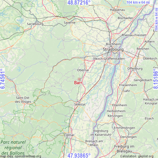
Barr GPS coordinates[2]
48° 24' 27.18" North, 7° 26' 55.428" East
| Map corner | latitude | longitude |
|---|---|---|
| Upper-left | 48.87216°, | 6.74561° |
| Center: | 48.40755°, | 7.44873° |
| Lower-right: | 47.93865°, | 8.15186° |
| Map W x H: | 103.8×103.8 km | = 64.5×64.5mi |
| max Lat: | 51.07786° ⇑33.5% North |
| Barr: | 48.40755° |
| min Lat: | ⇓66.5% South 41.3874° |
| min Long | Barr | max Long |
| -5.08615° | 7.44873° | 9.52242° |
| W 97.6%⇐ | ⇒2.4% E |
Elevation
Elevation of Barr is 208 m = 682 ft, and this is 14.3 m = 47 ft above average elevation for this country.
| Max E: |
2333 m = 7654 ft | 32.2% |
| Barr | 208 m 682 ft | |
| Avg. | 193.7 m = 635 ft | |
Min E: |
-1 m = -3 ft | 67.8% |
See also: France elevation on elevation.city.
Geographical zone
Barr is located in North temperate zone (between Tropic of Cancer and the Arctic Circle). Distance of this North polar circle is 2018.8 km =1254.4 mi to North.| Distance of | km | miles | from Barr |
|---|---|---|---|
| North Pole | 4624.6 | 2873.6 | to North |
| Arctic Circle | 2018.8 | 1254.4 | to North |
| Tropic Cancer | 2776.5 | 1725.2 | to South |
| Equator | 5382.4 | 3344.5 | to South |


Nearby cities:
15 places around Barr: (largest is in red/bold)
• Andlau
3.3 km =2.1 mi,  224°
224°
• Bernardswiller
4.9 km =3 mi,  11°
11°
• Epfig
5.5 km =3.4 mi,  167°
167°
• Gertwiller
1.5 km =0.9 mi,  75°
75°
• Goxwiller
3.8 km =2.4 mi,  44°
44°
• Heiligenstein
1.7 km =1.1 mi,  2°
2°
• Mittelbergheim
1.4 km =0.9 mi,  202°
202°
• Niedernai
6.9 km =4.3 mi,  45°
45°
• Obernai
6.6 km =4.1 mi,  21°
21°
• Ottrott
5.7 km =3.5 mi,  342°
342°
• Saint-Nabor
4.7 km =2.9 mi, 336°
• Saint-Pierre
3.1 km =1.9 mi,  145°
145°
• Stotzheim
4.5 km =2.8 mi,  134°
134°
• Valff
5.5 km =3.4 mi,  73°
73°
• Zellwiller
3.7 km =2.3 mi,  107°
107°
Sources, notices
• [Note1] Compared only with cities in France existing in our database
• [Src1] Map data: © OpenStreetMap contributors (CC-BY-SA)
• [Src2] Other city data from geonames.org with taken over terms of usage.
• [Src3] Geographical zone / Annual Mean Temperature by Robert A. Rohde @ Wikipedia
