Epfig geodata
Epfig (Grand Est) is a populated place; located in France in Europe/Paris (GMT+2) time zone. With population of 2,010 people, there are 4773 cities with bigger population in this country. Compared to other cities in France, 65.6% of cities are located further ↓South; 97.7% of cities are located further ←West and 69.8% of cities have lower elevation than Epfig. Note1
Administrative division(s):
- Level 1: Grand Est
- Level 2: Bas-Rhin
- Level 3: Arrondissement de Sélestat-Erstein
- Level 4: Epfig


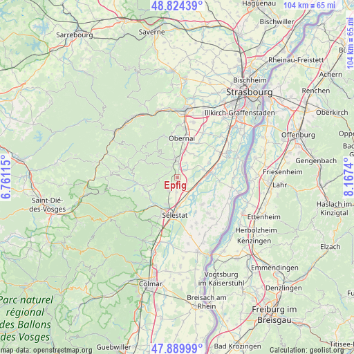
Epfig GPS coordinates[2]
48° 21' 33.588" North, 7° 27' 51.372" East
| Map corner | latitude | longitude |
|---|---|---|
| Upper-left | 48.82439°, | 6.76115° |
| Center: | 48.35933°, | 7.46427° |
| Lower-right: | 47.88999°, | 8.1674° |
| Map W x H: | 103.9×103.9 km | = 64.6×64.6mi |
| max Lat: | 51.07786° ⇑34.4% North |
| Epfig: | 48.35933° |
| min Lat: | ⇓65.6% South 41.3874° |
| min Long | Epfig | max Long |
| -5.08615° | 7.46427° | 9.52242° |
| W 97.7%⇐ | ⇒2.3% E |
Elevation
Elevation of Epfig is 218 m = 715 ft, and this is 24.3 m = 80 ft above average elevation for this country.
| Max E: |
2333 m = 7654 ft | 30.2% |
| Epfig | 218 m 715 ft | |
| Avg. | 193.7 m = 635 ft | |
Min E: |
-1 m = -3 ft | 69.8% |
See also: France elevation on elevation.city.
Geographical zone
Epfig is located in North temperate zone (between Tropic of Cancer and the Arctic Circle). Distance of this North polar circle is 2024.1 km =1257.7 mi to North.| Distance of | km | miles | from Epfig |
|---|---|---|---|
| North Pole | 4630 | 2876.9 | to North |
| Arctic Circle | 2024.1 | 1257.7 | to North |
| Tropic Cancer | 2771.1 | 1721.9 | to South |
| Equator | 5377.1 | 3341.2 | to South |


Nearby cities:
15 places around Epfig: (largest is in red/bold)
• Andlau
4.6 km =2.9 mi,  310°
310°
• Barr
5.5 km =3.4 mi,  347°
347°
• Dambach-la-Ville
4.9 km =3 mi,  215°
215°
• Ebersheim
6.6 km =4.1 mi,  157°
157°
• Ebersmunster
7 km =4.3 mi,  140°
140°
• Gertwiller
5.7 km =3.5 mi,  2°
2°
• Heiligenstein
7.1 km =4.4 mi, 351°
• Kertzfeld
8 km =5 mi,  73°
73°
• Kogenheim
6.3 km =3.9 mi,  112°
112°
• Mittelbergheim
4.4 km =2.7 mi,  337°
337°
• Saint-Pierre
2.9 km =1.8 mi,  12°
12°
• Sermersheim
6.7 km =4.2 mi,  102°
102°
• Stotzheim
3 km =1.9 mi,  43°
43°
• Valff
8.1 km =5 mi,  31°
31°
• Zellwiller
4.9 km =3 mi, 29°
Sources, notices
• [Note1] Compared only with cities in France existing in our database
• [Src1] Map data: © OpenStreetMap contributors (CC-BY-SA)
• [Src2] Other city data from geonames.org with taken over terms of usage.
• [Src3] Geographical zone / Annual Mean Temperature by Robert A. Rohde @ Wikipedia
