Saint-Père-en-Retz geodata
Saint-Père-en-Retz (Pays de la Loire) is a populated place; located in France in Europe/Paris (GMT+2) time zone. With population of 3,882 people, there are 2532 cities with bigger population in this country. Compared to other cities in France, 52.9% of cities are located further ↑North; 95% of cities are located further →East and 94.7% of cities have higher elevation than Saint-Père-en-Retz. Note1
Administrative division(s):
- Level 1: Pays de la Loire
- Level 2: Loire-Atlantique
- Level 3: Arrondissement de Saint-Nazaire
- Level 4: Saint-Père-en-Retz


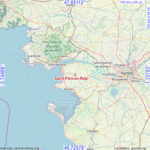
Saint-Père-en-Retz GPS coordinates[2]
47° 12' 20.124" North, 2° 2' 27.42" West
| Map corner | latitude | longitude |
|---|---|---|
| Upper-left | 47.68112°, | -2.74408° |
| Center: | 47.20559°, | -2.04095° |
| Lower-right: | 46.72576°, | -1.33783° |
| Map W x H: | 106.2×106.2 km | = 66×66mi |
| max Lat: | 51.07786° ⇑52.9% North |
| Saint-Père-en-Retz: | 47.20559° |
| min Lat: | ⇓47.1% South 41.3874° |
| min Long | Saint-Père-en- | max Long |
| -5.08615° | -2.04095° | 9.52242° |
| W 5%⇐ | ⇒95% E |
Elevation
Elevation of Saint-Père-en-Retz is 18 m = 59 ft, and this is 175.7 m = 576 ft below average elevation for this country.
| Max E: |
2333 m = 7654 ft | 94.7% |
| Avg. | 193.7 m = 635 ft | |
| Saint-Père-en-Retz | 18 m = 59 ft | |
Min E: |
-1 m = -3 ft | 5.3% |
See also: France elevation on elevation.city.
Geographical zone
Saint-Père-en-Retz is located in North temperate zone (between Tropic of Cancer and the Arctic Circle). Distance of this North polar circle is 2152.4 km =1337.4 mi to North.| Distance of | km | miles | from Saint-Père-en-Retz |
|---|---|---|---|
| North Pole | 4758.3 | 2956.7 | to North |
| Arctic Circle | 2152.4 | 1337.4 | to North |
| Tropic Cancer | 2642.9 | 1642.2 | to South |
| Equator | 5248.8 | 3261.5 | to South |


Nearby cities:
15 places around Saint-Père-en-Retz: (largest is in red/bold)
• Arthon-en-Retz
12.4 km =7.7 mi,  143°
143°
• Chauvé
7.3 km =4.5 mi, 144°
• Chéméré
13.6 km =8.5 mi, 136°
• Corsept
8.1 km =5 mi,  350°
350°
• Donges
12.8 km =8 mi, 348°
• Frossay
9.1 km =5.7 mi,  61°
61°
• La Plaine-sur-Mer
13.8 km =8.6 mi,  235°
235°
• Lavau-sur-Loire
12.6 km =7.8 mi,  26°
26°
• Paimboeuf
9 km =5.6 mi,  5°
5°
• Pornic
11 km =6.8 mi,  199°
199°
• Rouans
13.9 km =8.6 mi,  100°
100°
• Saint-Brevin-les-Pins
10.7 km =6.6 mi,  297°
297°
• Saint-Michel-Chef-Chef
8.6 km =5.3 mi,  251°
251°
• Saint-Viaud
5.9 km =3.7 mi,  16°
16°
• Vue
12.4 km =7.7 mi,  93°
93°
Sources, notices
• [Note1] Compared only with cities in France existing in our database
• [Src1] Map data: © OpenStreetMap contributors (CC-BY-SA)
• [Src2] Other city data from geonames.org with taken over terms of usage.
• [Src3] Geographical zone / Annual Mean Temperature by Robert A. Rohde @ Wikipedia
