Donges geodata
Donges (Pays de la Loire) is a populated place; located in France in Europe/Paris (GMT+2) time zone. With population of 6,749 people, there are 1473 cities with bigger population in this country. Compared to other cities in France, 51.2% of cities are located further ↑North; 95.1% of cities are located further →East and 97.4% of cities have higher elevation than Donges. Note1
Administrative division(s):
- Level 1: Pays de la Loire
- Level 2: Loire-Atlantique
- Level 3: Arrondissement de Saint-Nazaire
- Level 4: Donges


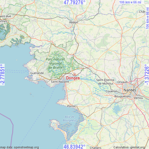
Donges GPS coordinates[2]
47° 19' 5.664" North, 2° 4' 31.368" West
| Map corner | latitude | longitude |
|---|---|---|
| Upper-left | 47.79276°, | -2.77851° |
| Center: | 47.31824°, | -2.07538° |
| Lower-right: | 46.83942°, | -1.37226° |
| Map W x H: | 106×106 km | = 65.9×65.9mi |
| max Lat: | 51.07786° ⇑51.2% North |
| Donges: | 47.31824° |
| min Lat: | ⇓48.8% South 41.3874° |
| min Long | Donges | max Long |
| -5.08615° | -2.07538° | 9.52242° |
| W 4.9%⇐ | ⇒95.1% E |
Elevation
Elevation of Donges is 10 m = 33 ft, and this is 183.7 m = 603 ft below average elevation for this country.
| Max E: |
2333 m = 7654 ft | 97.4% |
| Avg. | 193.7 m = 635 ft | |
| Donges | 10 m = 33 ft | |
Min E: |
-1 m = -3 ft | 2.6% |
See also: France elevation on elevation.city.
Geographical zone
Donges is located in North temperate zone (between Tropic of Cancer and the Arctic Circle). Distance of this North polar circle is 2139.9 km =1329.7 mi to North.| Distance of | km | miles | from Donges |
|---|---|---|---|
| North Pole | 4745.8 | 2948.9 | to North |
| Arctic Circle | 2139.9 | 1329.7 | to North |
| Tropic Cancer | 2655.4 | 1650 | to South |
| Equator | 5261.3 | 3269.2 | to South |


Nearby cities:
15 places around Donges: (largest is in red/bold)
• Besné
9.2 km =5.7 mi,  353°
353°
• Corsept
4.7 km =2.9 mi,  164°
164°
• La Chapelle-Launay
9.9 km =6.2 mi,  52°
52°
• Lavau-sur-Loire
8.3 km =5.2 mi,  98°
98°
• Le Pin
7.7 km =4.8 mi,  297°
297°
• Montoir-de-Bretagne
5.9 km =3.7 mi,  283°
283°
• Paimboeuf
4.9 km =3 mi,  136°
136°
• Prinquiau
7 km =4.3 mi, 45°
• Saint-Brevin-les-Pins
10.2 km =6.3 mi,  222°
222°
• Saint-Joachim
11.4 km =7.1 mi,  309°
309°
• Saint-Malo-de-Guersac
8.6 km =5.3 mi, 296°
• Saint-Nazaire
11 km =6.8 mi,  247°
247°
• Saint-Viaud
8.1 km =5 mi,  148°
148°
• Savenay
11.1 km =6.9 mi,  64°
64°
• Trignac
8.6 km =5.3 mi,  269°
269°
Sources, notices
• [Note1] Compared only with cities in France existing in our database
• [Src1] Map data: © OpenStreetMap contributors (CC-BY-SA)
• [Src2] Other city data from geonames.org with taken over terms of usage.
• [Src3] Geographical zone / Annual Mean Temperature by Robert A. Rohde @ Wikipedia
