Saint-Michel-Chef-Chef geodata
Saint-Michel-Chef-Chef (Pays de la Loire) is a populated place; located in France in Europe/Paris (GMT+2) time zone. With population of 3,435 people, there are 2828 cities with bigger population in this country. Compared to other cities in France, 53.3% of cities are located further ↑North; 95.4% of cities are located further →East and 92% of cities have higher elevation than Saint-Michel-Chef-Chef. Note1
Administrative division(s):
- Level 1: Pays de la Loire
- Level 2: Loire-Atlantique
- Level 3: Arrondissement de Saint-Nazaire
- Level 4: Saint-Michel-Chef-Chef


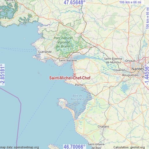
Saint-Michel-Chef-Chef GPS coordinates[2]
47° 10' 50.592" North, 2° 8' 55.284" West
| Map corner | latitude | longitude |
|---|---|---|
| Upper-left | 47.65648°, | -2.85181° |
| Center: | 47.18072°, | -2.14869° |
| Lower-right: | 46.70066°, | -1.44556° |
| Map W x H: | 106.3×106.3 km | = 66.1×66.1mi |
| max Lat: | 51.07786° ⇑53.3% North |
| Saint-Michel-Chef-Chef: | 47.18072° |
| min Lat: | ⇓46.7% South 41.3874° |
| min Long | Saint-Michel-Ch | max Long |
| -5.08615° | -2.14869° | 9.52242° |
| W 4.6%⇐ | ⇒95.4% E |
Elevation
Elevation of Saint-Michel-Chef-Chef is 25 m = 82 ft, and this is 168.7 m = 553 ft below average elevation for this country.
| Max E: |
2333 m = 7654 ft | 92% |
| Avg. | 193.7 m = 635 ft | |
| Saint-Michel-Chef-Chef | 25 m = 82 ft | |
Min E: |
-1 m = -3 ft | 8% |
See also: France elevation on elevation.city.
Geographical zone
Saint-Michel-Chef-Chef is located in North temperate zone (between Tropic of Cancer and the Arctic Circle). Distance of this North polar circle is 2155.2 km =1339.2 mi to North.| Distance of | km | miles | from Saint-Michel-Chef-Chef |
|---|---|---|---|
| North Pole | 4761.1 | 2958.4 | to North |
| Arctic Circle | 2155.2 | 1339.2 | to North |
| Tropic Cancer | 2640.1 | 1640.5 | to South |
| Equator | 5246 | 3259.7 | to South |


Nearby cities:
15 places around Saint-Michel-Chef-Chef: (largest is in red/bold)
• Arthon-en-Retz
17.2 km =10.7 mi,  114°
114°
• Chauvé
12.8 km =8 mi,  104°
104°
• Corsept
12.7 km =7.9 mi,  32°
32°
• Donges
16.3 km =10.1 mi,  19°
19°
• La Bernerie-en-Retz
14 km =8.7 mi,  142°
142°
• La Plaine-sur-Mer
5.9 km =3.7 mi,  213°
213°
• Montoir-de-Bretagne
16.6 km =10.3 mi,  359°
359°
• Paimboeuf
14.8 km =9.2 mi,  37°
37°
• Pornic
8.9 km =5.5 mi,  149°
149°
• Préfailles
7.8 km =4.8 mi,  221°
221°
• Saint-Brevin-les-Pins
7.8 km =4.8 mi,  350°
350°
• Saint-Nazaire
11.9 km =7.4 mi,  337°
337°
• Saint-Père-en-Retz
8.6 km =5.3 mi,  71°
71°
• Saint-Viaud
12.9 km =8 mi,  49°
49°
• Trignac
15.6 km =9.7 mi, 348°
Sources, notices
• [Note1] Compared only with cities in France existing in our database
• [Src1] Map data: © OpenStreetMap contributors (CC-BY-SA)
• [Src2] Other city data from geonames.org with taken over terms of usage.
• [Src3] Geographical zone / Annual Mean Temperature by Robert A. Rohde @ Wikipedia
