Murviel-lès-Montpellier geodata
Murviel-lès-Montpellier (Occitanie) is a populated place; located in France in Europe/Paris (GMT+2) time zone. With population of 1,352 people, there are 6802 cities with bigger population in this country. Compared to other cities in France, 91.8% of cities are located further ↑North; 66% of cities are located further ←West and 50.2% of cities have higher elevation than Murviel-lès-Montpellier. Note1
Administrative division(s):
- Level 1: Occitanie
- Level 2: Département de l'Hérault
- Level 3: Arrondissement of Montpellier
- Level 4: Murviel-lès-Montpellier
Current local time in Murviel-lès-Montpellier:
12:35 PM, MondayDifference from your time zone: hours


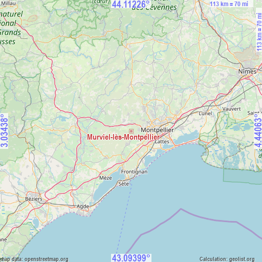
Murviel-lès-Montpellier GPS coordinates[2]
43° 36' 19.008" North, 3° 44' 15" East
| Map corner | latitude | longitude |
|---|---|---|
| Upper-left | 44.11226°, | 3.03438° |
| Center: | 43.60528°, | 3.7375° |
| Lower-right: | 43.09399°, | 4.44063° |
| Map W x H: | 113.2×113.2 km | = 70.3×70.3mi |
| max Lat: | 51.07786° ⇑91.8% North |
| Murviel-lès-Montpellier: | 43.60528° |
| min Lat: | ⇓8.2% South 41.3874° |
| min Long | Murviel-lès-Mo | max Long |
| -5.08615° | 3.7375° | 9.52242° |
| W 66%⇐ | ⇒34% E |
Elevation
Elevation of Murviel-lès-Montpellier is 131 m = 430 ft, and this is 62.7 m = 206 ft below average elevation for this country.
| Max E: |
2333 m = 7654 ft | 50.2% |
| Avg. | 193.7 m = 635 ft | |
| Murviel-lès-Montpellier | 131 m = 430 ft | |
Min E: |
-1 m = -3 ft | 49.8% |
See also: France elevation on elevation.city.
Geographical zone
Murviel-lès-Montpellier is located in North temperate zone (between Tropic of Cancer and the Arctic Circle). Distance of this Northern Tropic circle is 2242.5 km =1393.4 mi to South.| Distance of | km | miles | from Murviel-lès-Montpellier |
|---|---|---|---|
| North Pole | 5158.6 | 3205.4 | to North |
| Arctic Circle | 2552.7 | 1586.2 | to North |
| Tropic Cancer | 2242.5 | 1393.4 | to South |
| Equator | 4848.5 | 3012.7 | to South |


Nearby cities:
15 places around Murviel-lès-Montpellier: (largest is in red/bold)
• Combaillaux
7.8 km =4.8 mi,  18°
18°
• Cournonsec
6.7 km =4.2 mi,  202°
202°
• Cournonterral
5.3 km =3.3 mi, 195°
• Fabrègues
6.8 km =4.2 mi,  152°
152°
• Grabels
6.8 km =4.2 mi,  46°
46°
• Juvignac
6 km =3.7 mi,  80°
80°
• Lavérune
5.9 km =3.7 mi,  110°
110°
• Montarnaud
5.7 km =3.5 mi,  325°
325°
• Montbazin
10.4 km =6.5 mi, 198°
• Pignan
3 km =1.9 mi,  143°
143°
• Saint-Gély-du-Fesc
11.1 km =6.9 mi,  29°
29°
• Saint-Jean-de-Védas
7.8 km =4.8 mi, 113°
• Saint-Paul-et-Valmalle
5.6 km =3.5 mi,  296°
296°
• Saussan
4.8 km =3 mi, 140°
• Vailhauquès
7.5 km =4.7 mi,  349°
349°
Sources, notices
• [Note1] Compared only with cities in France existing in our database
• [Src1] Map data: © OpenStreetMap contributors (CC-BY-SA)
• [Src2] Other city data from geonames.org with taken over terms of usage.
• [Src3] Geographical zone / Annual Mean Temperature by Robert A. Rohde @ Wikipedia
