Saint-Pair-sur-Mer geodata
Saint-Pair-sur-Mer (Normandy) is a populated place; located in France in Europe/Paris (GMT+2) time zone. With population of 3,741 people, there are 2629 cities with bigger population in this country. Compared to other cities in France, 75.8% of cities are located further ↓South; 92.7% of cities are located further →East and 93.1% of cities have higher elevation than Saint-Pair-sur-Mer. Note1
Administrative division(s):
- Level 1: Normandy
- Level 2: Manche
- Level 3: Avranches
- Level 4: Saint-Pair-sur-Mer


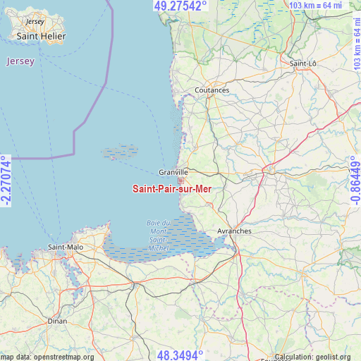
Saint-Pair-sur-Mer GPS coordinates[2]
48° 48' 52.38" North, 1° 34' 3.396" West
| Map corner | latitude | longitude |
|---|---|---|
| Upper-left | 49.27542°, | -2.27074° |
| Center: | 48.81455°, | -1.56761° |
| Lower-right: | 48.3494°, | -0.86449° |
| Map W x H: | 103×103 km | = 64×64mi |
| max Lat: | 51.07786° ⇑24.2% North |
| Saint-Pair-sur-Mer: | 48.81455° |
| min Lat: | ⇓75.8% South 41.3874° |
| min Long | Saint-Pair-sur- | max Long |
| -5.08615° | -1.56761° | 9.52242° |
| W 7.3%⇐ | ⇒92.7% E |
Elevation
Elevation of Saint-Pair-sur-Mer is 22 m = 72 ft, and this is 171.7 m = 563 ft below average elevation for this country.
| Max E: |
2333 m = 7654 ft | 93.1% |
| Avg. | 193.7 m = 635 ft | |
| Saint-Pair-sur-Mer | 22 m = 72 ft | |
Min E: |
-1 m = -3 ft | 6.9% |
See also: France elevation on elevation.city.
Geographical zone
Saint-Pair-sur-Mer is located in North temperate zone (between Tropic of Cancer and the Arctic Circle). Distance of this North polar circle is 1973.5 km =1226.3 mi to North.| Distance of | km | miles | from Saint-Pair-sur-Mer |
|---|---|---|---|
| North Pole | 4579.4 | 2845.5 | to North |
| Arctic Circle | 1973.5 | 1226.3 | to North |
| Tropic Cancer | 2821.8 | 1753.4 | to South |
| Equator | 5427.7 | 3372.6 | to South |


Nearby cities:
15 places around Saint-Pair-sur-Mer: (largest is in red/bold)
• Bricqueville-sur-Mer
11.5 km =7.1 mi,  17°
17°
• Bréhal
10.2 km =6.3 mi, 23°
• Bréville-sur-Mer
5.7 km =3.5 mi,  8°
8°
• Carolles
7.1 km =4.4 mi,  175°
175°
• Coudeville-sur-Mer
8 km =5 mi, 21°
• Donville-les-Bains
3.7 km =2.3 mi,  342°
342°
• Dragey-Ronthon
12 km =7.5 mi,  155°
155°
• Folligny
11.5 km =7.1 mi,  84°
84°
• Granville
3.4 km =2.1 mi,  320°
320°
• Hudimesnil
7.7 km =4.8 mi,  45°
45°
• Jullouville
4.3 km =2.7 mi, 176°
• Saint-Jean-des-Champs
7.7 km =4.8 mi, 78°
• Saint-Planchers
3.2 km =2 mi,  73°
73°
• Sartilly
10.7 km =6.6 mi,  130°
130°
• Yquelon
3.8 km =2.4 mi, 12°
Sources, notices
• [Note1] Compared only with cities in France existing in our database
• [Src1] Map data: © OpenStreetMap contributors (CC-BY-SA)
• [Src2] Other city data from geonames.org with taken over terms of usage.
• [Src3] Geographical zone / Annual Mean Temperature by Robert A. Rohde @ Wikipedia
