Carolles geodata
Carolles (Normandy) is a populated place; located in France in Europe/Paris (GMT+2) time zone. With population of 558 people, there are 14045 cities with bigger population in this country. Compared to other cities in France, 74.4% of cities are located further ↓South; 92.7% of cities are located further →East and 79.8% of cities have higher elevation than Carolles. Note1


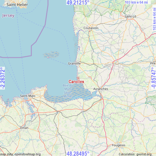
Carolles GPS coordinates[2]
48° 45' 2.484" North, 1° 33' 38.16" West
| Map corner | latitude | longitude |
|---|---|---|
| Upper-left | 49.21215°, | -2.26372° |
| Center: | 48.75069°, | -1.5606° |
| Lower-right: | 48.28495°, | -0.85747° |
| Map W x H: | 103.1×103.1 km | = 64.1×64.1mi |
| max Lat: | 51.07786° ⇑25.6% North |
| Carolles: | 48.75069° |
| min Lat: | ⇓74.4% South 41.3874° |
| min Long | Carolles | max Long |
| -5.08615° | -1.5606° | 9.52242° |
| W 7.3%⇐ | ⇒92.7% E |
Elevation
Elevation of Carolles is 55 m = 180 ft, and this is 138.7 m = 455 ft below average elevation for this country.
| Max E: |
2333 m = 7654 ft | 79.8% |
| Avg. | 193.7 m = 635 ft | |
| Carolles | 55 m = 180 ft | |
Min E: |
-1 m = -3 ft | 20.2% |
See also: France elevation on elevation.city.
Geographical zone
Carolles is located in North temperate zone (between Tropic of Cancer and the Arctic Circle). Distance of this North polar circle is 1980.6 km =1230.7 mi to North.| Distance of | km | miles | from Carolles |
|---|---|---|---|
| North Pole | 4586.5 | 2849.9 | to North |
| Arctic Circle | 1980.6 | 1230.7 | to North |
| Tropic Cancer | 2814.6 | 1748.9 | to South |
| Equator | 5420.6 | 3368.2 | to South |


Nearby cities:
15 places around Carolles: (largest is in red/bold)
• Bacilly
10.4 km =6.5 mi,  122°
122°
• Bréville-sur-Mer
12.8 km =8 mi,  1°
1°
• Donville-les-Bains
10.7 km =6.6 mi,  351°
351°
• Dragey-Ronthon
5.8 km =3.6 mi,  130°
130°
• Granville
10.1 km =6.3 mi,  344°
344°
• Hudimesnil
13.4 km =8.3 mi,  21°
21°
• Jullouville
2.8 km =1.7 mi,  355°
355°
• La Haye-Pesnel
13 km =8.1 mi,  67°
67°
• Lolif
12.4 km =7.7 mi,  98°
98°
• Saint-Jean-des-Champs
11.1 km =6.9 mi,  39°
39°
• Saint-Pair-sur-Mer
7.1 km =4.4 mi, 355°
• Saint-Planchers
8.4 km =5.2 mi, 17°
• Sartilly
7.6 km =4.7 mi,  88°
88°
• Vains
13.3 km =8.3 mi, 125°
• Yquelon
10.8 km =6.7 mi, 1°
Sources, notices
• [Note1] Compared only with cities in France existing in our database
• [Src1] Map data: © OpenStreetMap contributors (CC-BY-SA)
• [Src2] Other city data from geonames.org with taken over terms of usage.
• [Src3] Geographical zone / Annual Mean Temperature by Robert A. Rohde @ Wikipedia
