Amboise geodata
Amboise (Centre) is a populated place; located in France in Europe/Paris (GMT+2) time zone. With population of 12,685 people, there are 748 cities with bigger population in this country. Compared to other cities in France, 50.1% of cities are located further ↓South; 68.9% of cities are located further →East and 77.3% of cities have higher elevation than Amboise. Note1
Administrative division(s):
- Level 1: Centre
- Level 2: Département d'Indre-et-Loire
- Level 3: Arrondissement de Loches
- Level 4: Amboise


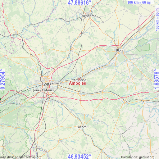
Amboise GPS coordinates[2]
47° 24' 44.964" North, 0° 58' 57.576" East
| Map corner | latitude | longitude |
|---|---|---|
| Upper-left | 47.88616°, | 0.27954° |
| Center: | 47.41249°, | 0.98266° |
| Lower-right: | 46.93452°, | 1.68579° |
| Map W x H: | 105.8×105.8 km | = 65.7×65.7mi |
| max Lat: | 51.07786° ⇑49.9% North |
| Amboise: | 47.41249° |
| min Lat: | ⇓50.1% South 41.3874° |
| min Long | Amboise | max Long |
| -5.08615° | 0.98266° | 9.52242° |
| W 31.1%⇐ | ⇒68.9% E |
Elevation
Elevation of Amboise is 61 m = 200 ft, and this is 132.7 m = 435 ft below average elevation for this country.
| Max E: |
2333 m = 7654 ft | 77.3% |
| Avg. | 193.7 m = 635 ft | |
| Amboise | 61 m = 200 ft | |
Min E: |
-1 m = -3 ft | 22.7% |
See also: France elevation on elevation.city.
Geographical zone
Amboise is located in North temperate zone (between Tropic of Cancer and the Arctic Circle). Distance of this North polar circle is 2129.4 km =1323.1 mi to North.| Distance of | km | miles | from Amboise |
|---|---|---|---|
| North Pole | 4735.3 | 2942.4 | to North |
| Arctic Circle | 2129.4 | 1323.1 | to North |
| Tropic Cancer | 2665.9 | 1656.5 | to South |
| Equator | 5271.8 | 3275.7 | to South |


Nearby cities:
15 places around Amboise: (largest is in red/bold)
• Bléré
9.5 km =5.9 mi,  175°
175°
• Cangey
8.4 km =5.2 mi,  43°
43°
• Chançay
9.4 km =5.8 mi,  299°
299°
• Chargé
4.2 km =2.6 mi,  57°
57°
• Dierre
7.7 km =4.8 mi,  194°
194°
• La Croix-en-Touraine
8 km =5 mi, 175°
• Limeray
6.8 km =4.2 mi, 39°
• Lussault-sur-Loire
5.4 km =3.4 mi,  248°
248°
• Montreuil-en-Touraine
8.8 km =5.5 mi,  343°
343°
• Mosnes
10 km =6.2 mi, 61°
• Nazelles-Négron
3.4 km =2.1 mi,  313°
313°
• Noizay
6.9 km =4.3 mi,  278°
278°
• Pocé-sur-Cisse
3.5 km =2.2 mi,  10°
10°
• Saint-Martin-le-Beau
8.4 km =5.2 mi,  221°
221°
• Saint-Ouen-les-Vignes
6.2 km =3.9 mi, 8°
Sources, notices
• [Note1] Compared only with cities in France existing in our database
• [Src1] Map data: © OpenStreetMap contributors (CC-BY-SA)
• [Src2] Other city data from geonames.org with taken over terms of usage.
• [Src3] Geographical zone / Annual Mean Temperature by Robert A. Rohde @ Wikipedia
