Le Breil-sur-Mérize geodata
Le Breil-sur-Mérize (Pays de la Loire) is a populated place; located in France in Europe/Paris (GMT+2) time zone. With population of 1,181 people, there are 7641 cities with bigger population in this country. Compared to other cities in France, 59.4% of cities are located further ↓South; 73.6% of cities are located further →East and 57.3% of cities have higher elevation than Le Breil-sur-Mérize. Note1
Administrative division(s):
- Level 1: Pays de la Loire
- Level 2: Sarthe
- Level 3: Arrondissement de Mamers
- Level 4: Le Breil-sur-Mérize


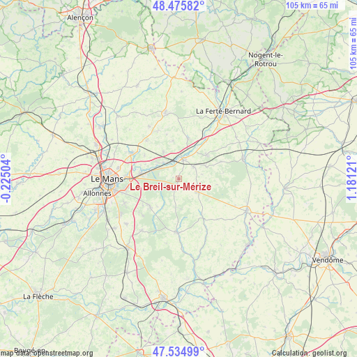
Le Breil-sur-Mérize GPS coordinates[2]
48° 0' 27.18" North, 0° 28' 41.088" East
| Map corner | latitude | longitude |
|---|---|---|
| Upper-left | 48.47582°, | -0.22504° |
| Center: | 48.00755°, | 0.47808° |
| Lower-right: | 47.53499°, | 1.18121° |
| Map W x H: | 104.6×104.6 km | = 65×65mi |
| max Lat: | 51.07786° ⇑40.6% North |
| Le Breil-sur-Mérize: | 48.00755° |
| min Lat: | ⇓59.4% South 41.3874° |
| min Long | Le Breil-sur-M� | max Long |
| -5.08615° | 0.47808° | 9.52242° |
| W 26.4%⇐ | ⇒73.6% E |
Elevation
Elevation of Le Breil-sur-Mérize is 110 m = 361 ft, and this is 83.7 m = 275 ft below average elevation for this country.
| Max E: |
2333 m = 7654 ft | 57.3% |
| Avg. | 193.7 m = 635 ft | |
| Le Breil-sur-Mérize | 110 m = 361 ft | |
Min E: |
-1 m = -3 ft | 42.7% |
See also: France elevation on elevation.city.
Geographical zone
Le Breil-sur-Mérize is located in North temperate zone (between Tropic of Cancer and the Arctic Circle). Distance of this North polar circle is 2063.2 km =1282 mi to North.| Distance of | km | miles | from Le Breil-sur-Mérize |
|---|---|---|---|
| North Pole | 4669.1 | 2901.2 | to North |
| Arctic Circle | 2063.2 | 1282 | to North |
| Tropic Cancer | 2732 | 1697.6 | to South |
| Equator | 5337.9 | 3316.8 | to South |


Nearby cities:
15 places around Le Breil-sur-Mérize: (largest is in red/bold)
• Bouloire
6.5 km =4 mi,  124°
124°
• Challes
9.8 km =6.1 mi,  208°
208°
• Champagné
11.1 km =6.9 mi,  278°
278°
• Connerré
5.6 km =3.5 mi,  11°
11°
• Dollon
8.8 km =5.5 mi,  66°
66°
• Duneau
7.4 km =4.6 mi,  24°
24°
• Fatines
10.6 km =6.6 mi,  293°
293°
• Le Luart
10.6 km =6.6 mi,  48°
48°
• Lombron
9.1 km =5.7 mi,  330°
330°
• Montfort-le-Gesnois
6.6 km =4.1 mi,  315°
315°
• Saint-Mars-la-Brière
8.2 km =5.1 mi, 288°
• Saint-Michel-de-Chavaignes
7.1 km =4.4 mi,  80°
80°
• Soulitré
1.7 km =1.1 mi, 282°
• Thorigné-sur-Dué
5.5 km =3.4 mi, 50°
• Volnay
8.3 km =5.2 mi,  185°
185°
Sources, notices
• [Note1] Compared only with cities in France existing in our database
• [Src1] Map data: © OpenStreetMap contributors (CC-BY-SA)
• [Src2] Other city data from geonames.org with taken over terms of usage.
• [Src3] Geographical zone / Annual Mean Temperature by Robert A. Rohde @ Wikipedia
