Montfort-le-Gesnois geodata
Montfort-le-Gesnois (Pays de la Loire) is a populated place; located in France in Europe/Paris (GMT+2) time zone. With population of 3,034 people, there are 3211 cities with bigger population in this country. Compared to other cities in France, 60.2% of cities are located further ↓South; 74.1% of cities are located further →East and 76.2% of cities have higher elevation than Montfort-le-Gesnois. Note1
Administrative division(s):
- Level 1: Pays de la Loire
- Level 2: Sarthe
- Level 3: Arrondissement de Mamers
- Level 4: Montfort-le-Gesnois


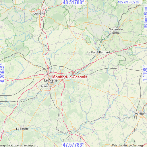
Montfort-le-Gesnois GPS coordinates[2]
48° 3' 0" North, 0° 25' 0.012" East
| Map corner | latitude | longitude |
|---|---|---|
| Upper-left | 48.51788°, | -0.28645° |
| Center: | 48.05°, | 0.41667° |
| Lower-right: | 47.57783°, | 1.1198° |
| Map W x H: | 104.5×104.5 km | = 64.9×64.9mi |
| max Lat: | 51.07786° ⇑39.8% North |
| Montfort-le-Gesnois: | 48.05° |
| min Lat: | ⇓60.2% South 41.3874° |
| min Long | Montfort-le-Ges | max Long |
| -5.08615° | 0.41667° | 9.52242° |
| W 25.9%⇐ | ⇒74.1% E |
Elevation
Elevation of Montfort-le-Gesnois is 64 m = 210 ft, and this is 129.7 m = 426 ft below average elevation for this country.
| Max E: |
2333 m = 7654 ft | 76.2% |
| Avg. | 193.7 m = 635 ft | |
| Montfort-le-Gesnois | 64 m = 210 ft | |
Min E: |
-1 m = -3 ft | 23.8% |
See also: France elevation on elevation.city.
Geographical zone
Montfort-le-Gesnois is located in North temperate zone (between Tropic of Cancer and the Arctic Circle). Distance of this North polar circle is 2058.5 km =1279.1 mi to North.| Distance of | km | miles | from Montfort-le-Gesnois |
|---|---|---|---|
| North Pole | 4664.4 | 2898.3 | to North |
| Arctic Circle | 2058.5 | 1279.1 | to North |
| Tropic Cancer | 2736.7 | 1700.5 | to South |
| Equator | 5342.7 | 3319.8 | to South |


Nearby cities:
15 places around Montfort-le-Gesnois: (largest is in red/bold)
• Beaufay
11.5 km =7.1 mi,  339°
339°
• Champagné
7.1 km =4.4 mi,  243°
243°
• Connerré
5.8 km =3.6 mi,  82°
82°
• Duneau
7.9 km =4.9 mi, 75°
• Fatines
5.1 km =3.2 mi,  264°
264°
• La Chapelle-Saint-Rémy
7.1 km =4.4 mi,  25°
25°
• Le Breil-sur-Mérize
6.6 km =4.1 mi,  135°
135°
• Lombron
3.2 km =2 mi,  2°
2°
• Saint-Corneille
5.7 km =3.5 mi,  288°
288°
• Saint-Mars-la-Brière
3.9 km =2.4 mi, 236°
• Sillé-le-Philippe
8 km =5 mi,  322°
322°
• Soulitré
5.2 km =3.2 mi,  146°
146°
• Thorigné-sur-Dué
8.9 km =5.5 mi,  97°
97°
• Torcé-en-Vallée
9.2 km =5.7 mi,  350°
350°
• Tuffé
10.2 km =6.3 mi,  46°
46°
Sources, notices
• [Note1] Compared only with cities in France existing in our database
• [Src1] Map data: © OpenStreetMap contributors (CC-BY-SA)
• [Src2] Other city data from geonames.org with taken over terms of usage.
• [Src3] Geographical zone / Annual Mean Temperature by Robert A. Rohde @ Wikipedia
