Saint-Nazaire geodata
Saint-Nazaire (Pays de la Loire) is a seat of a third-order administrative division; located in France in Europe/Paris (GMT+2) time zone. With population of 67,054 people, there are 70 cities with bigger population in this country. Compared to other cities in France, 51.8% of cities are located further ↑North; 95.6% of cities are located further →East and 99.6% of cities have higher elevation than Saint-Nazaire. Note1
Administrative division(s):
- Level 1: Pays de la Loire
- Level 2: Loire-Atlantique
- Level 3: Arrondissement de Saint-Nazaire
- Level 4: Saint-Nazaire


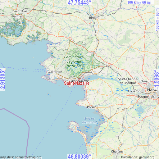
Saint-Nazaire GPS coordinates[2]
47° 16' 46.416" North, 2° 12' 35.748" West
| Map corner | latitude | longitude |
|---|---|---|
| Upper-left | 47.75443°, | -2.91305° |
| Center: | 47.27956°, | -2.20993° |
| Lower-right: | 46.80039°, | -1.5068° |
| Map W x H: | 106.1×106.1 km | = 65.9×65.9mi |
| max Lat: | 51.07786° ⇑51.8% North |
| Saint-Nazaire: | 47.27956° |
| min Lat: | ⇓48.2% South 41.3874° |
| min Long | Saint-Nazaire | max Long |
| -5.08615° | -2.20993° | 9.52242° |
| W 4.4%⇐ | ⇒95.6% E |
Elevation
Elevation of Saint-Nazaire is 4 m = 13 ft, and this is 189.7 m = 622 ft below average elevation for this country.
| Max E: |
2333 m = 7654 ft | 99.6% |
| Avg. | 193.7 m = 635 ft | |
| Saint-Nazaire | 4 m = 13 ft | |
Min E: |
-1 m = -3 ft | 0.4% |
See also: Saint-Nazaire elevation on elevation.city.
Geographical zone
Saint-Nazaire is located in North temperate zone (between Tropic of Cancer and the Arctic Circle). Distance of this North polar circle is 2144.2 km =1332.3 mi to North.| Distance of | km | miles | from Saint-Nazaire |
|---|---|---|---|
| North Pole | 4750.1 | 2951.6 | to North |
| Arctic Circle | 2144.2 | 1332.3 | to North |
| Tropic Cancer | 2651.1 | 1647.3 | to South |
| Equator | 5257 | 3266.5 | to South |


Nearby cities:
15 places around Saint-Nazaire: (largest is in red/bold)
• Corsept
11.4 km =7.1 mi,  91°
91°
• Crossac
14.9 km =9.3 mi,  11°
11°
• Donges
11 km =6.8 mi,  67°
67°
• La Baule-Escoublac
11.7 km =7.3 mi,  276°
276°
• Le Pin
8.5 km =5.3 mi,  22°
22°
• Montoir-de-Bretagne
7.2 km =4.5 mi,  38°
38°
• Paimboeuf
13.6 km =8.5 mi, 86°
• Pornichet
9.8 km =6.1 mi,  261°
261°
• Saint-André-des-Eaux
8.6 km =5.3 mi,  297°
297°
• Saint-Brevin-les-Pins
4.6 km =2.9 mi,  135°
135°
• Saint-Joachim
11.6 km =7.2 mi, 6°
• Saint-Malo-de-Guersac
8.6 km =5.3 mi, 16°
• Saint-Michel-Chef-Chef
11.9 km =7.4 mi,  157°
157°
• Saint-Viaud
14.7 km =9.1 mi,  100°
100°
• Trignac
4.6 km =2.9 mi, 20°
Sources, notices
• [Note1] Compared only with cities in France existing in our database
• [Src1] Map data: © OpenStreetMap contributors (CC-BY-SA)
• [Src2] Other city data from geonames.org with taken over terms of usage.
• [Src3] Geographical zone / Annual Mean Temperature by Robert A. Rohde @ Wikipedia
