Saint-Martin-sur-Oust geodata
Saint-Martin-sur-Oust (Brittany) is a populated place; located in France in Europe/Paris (GMT+2) time zone. With population of 1,384 people, there are 6668 cities with bigger population in this country. Compared to other cities in France, 55% of cities are located further ↓South; 95.7% of cities are located further →East and 97.4% of cities have higher elevation than Saint-Martin-sur-Oust. Note1
Administrative division(s):
- Level 1: Brittany
- Level 2: Morbihan
- Level 3: Arrondissement de Vannes
- Level 4: Saint-Martin-sur-Oust
Current local time in Saint-Martin-sur-Oust:
01:39 PM, WednesdayDifference from your time zone: hours


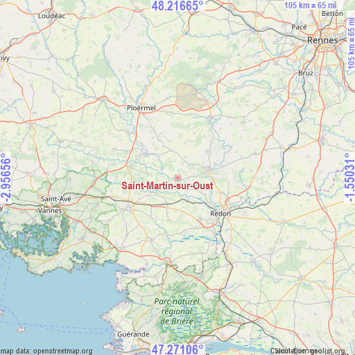
Saint-Martin-sur-Oust GPS coordinates[2]
47° 44' 45.6" North, 2° 15' 12.348" West
| Map corner | latitude | longitude |
|---|---|---|
| Upper-left | 48.21665°, | -2.95656° |
| Center: | 47.746°, | -2.25343° |
| Lower-right: | 47.27106°, | -1.55031° |
| Map W x H: | 105.1×105.1 km | = 65.3×65.3mi |
| max Lat: | 51.07786° ⇑45% North |
| Saint-Martin-sur-Oust: | 47.746° |
| min Lat: | ⇓55% South 41.3874° |
| min Long | Saint-Martin-su | max Long |
| -5.08615° | -2.25343° | 9.52242° |
| W 4.3%⇐ | ⇒95.7% E |
Elevation
Elevation of Saint-Martin-sur-Oust is 10 m = 33 ft, and this is 183.7 m = 603 ft below average elevation for this country.
| Max E: |
2333 m = 7654 ft | 97.4% |
| Avg. | 193.7 m = 635 ft | |
| Saint-Martin-sur-Oust | 10 m = 33 ft | |
Min E: |
-1 m = -3 ft | 2.6% |
See also: France elevation on elevation.city.
Geographical zone
Saint-Martin-sur-Oust is located in North temperate zone (between Tropic of Cancer and the Arctic Circle). Distance of this North polar circle is 2092.3 km =1300.1 mi to North.| Distance of | km | miles | from Saint-Martin-sur-Oust |
|---|---|---|---|
| North Pole | 4698.2 | 2919.3 | to North |
| Arctic Circle | 2092.3 | 1300.1 | to North |
| Tropic Cancer | 2702.9 | 1679.5 | to South |
| Equator | 5308.9 | 3298.8 | to South |


Nearby cities:
15 places around Saint-Martin-sur-Oust: (largest is in red/bold)
• Cournon
10.9 km =6.8 mi,  90°
90°
• Glénac
9.2 km =5.7 mi,  103°
103°
• La Gacilly
9.3 km =5.8 mi,  76°
76°
• Les Fougerêts
3.1 km =1.9 mi, 100°
• Malansac
8.3 km =5.2 mi,  202°
202°
• Peillac
4.4 km =2.7 mi,  144°
144°
• Pleucadeuc
9.1 km =5.7 mi,  278°
278°
• Pluherlin
9.9 km =6.2 mi,  236°
236°
• Rochefort-en-Terre
7.9 km =4.9 mi,  229°
229°
• Ruffiac
8.4 km =5.2 mi,  345°
345°
• Saint-Congard
5.5 km =3.4 mi,  299°
299°
• Saint-Gravé
3 km =1.9 mi,  221°
221°
• Saint-Jacut-les-Pins
7.3 km =4.5 mi,  156°
156°
• Saint-Vincent-sur-Oust
9.5 km =5.9 mi,  122°
122°
• Tréal
10.4 km =6.5 mi,  12°
12°
Sources, notices
• [Note1] Compared only with cities in France existing in our database
• [Src1] Map data: © OpenStreetMap contributors (CC-BY-SA)
• [Src2] Other city data from geonames.org with taken over terms of usage.
• [Src3] Geographical zone / Annual Mean Temperature by Robert A. Rohde @ Wikipedia
