Peillac geodata
Peillac (Brittany) is a populated place; located in France in Europe/Paris (GMT+2) time zone. With population of 1,787 people, there are 5310 cities with bigger population in this country. Compared to other cities in France, 54.4% of cities are located further ↓South; 95.6% of cities are located further →East and 75.8% of cities have higher elevation than Peillac. Note1
Administrative division(s):
- Level 1: Brittany
- Level 2: Morbihan
- Level 3: Arrondissement de Vannes
- Level 4: Peillac


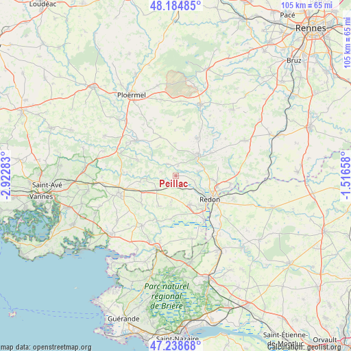
Peillac GPS coordinates[2]
47° 42' 50.076" North, 2° 13' 10.956" West
| Map corner | latitude | longitude |
|---|---|---|
| Upper-left | 48.18485°, | -2.92283° |
| Center: | 47.71391°, | -2.21971° |
| Lower-right: | 47.23868°, | -1.51658° |
| Map W x H: | 105.2×105.2 km | = 65.4×65.4mi |
| max Lat: | 51.07786° ⇑45.6% North |
| Peillac: | 47.71391° |
| min Lat: | ⇓54.4% South 41.3874° |
| min Long | Peillac | max Long |
| -5.08615° | -2.21971° | 9.52242° |
| W 4.4%⇐ | ⇒95.6% E |
Elevation
Elevation of Peillac is 65 m = 213 ft, and this is 128.7 m = 422 ft below average elevation for this country.
| Max E: |
2333 m = 7654 ft | 75.8% |
| Avg. | 193.7 m = 635 ft | |
| Peillac | 65 m = 213 ft | |
Min E: |
-1 m = -3 ft | 24.2% |
See also: France elevation on elevation.city.
Geographical zone
Peillac is located in North temperate zone (between Tropic of Cancer and the Arctic Circle). Distance of this North polar circle is 2095.9 km =1302.3 mi to North.| Distance of | km | miles | from Peillac |
|---|---|---|---|
| North Pole | 4701.8 | 2921.6 | to North |
| Arctic Circle | 2095.9 | 1302.3 | to North |
| Tropic Cancer | 2699.4 | 1677.3 | to South |
| Equator | 5305.3 | 3296.6 | to South |


Nearby cities:
15 places around Peillac: (largest is in red/bold)
• Allaire
9.5 km =5.9 mi,  153°
153°
• Caden
10.5 km =6.5 mi,  208°
208°
• Cournon
9.1 km =5.7 mi,  67°
67°
• Glénac
6.6 km =4.1 mi,  77°
77°
• La Gacilly
8.7 km =5.4 mi,  48°
48°
• Les Fougerêts
3 km =1.9 mi,  9°
9°
• Malansac
7 km =4.3 mi,  234°
234°
• Pluherlin
10.9 km =6.8 mi,  259°
259°
• Rochefort-en-Terre
8.6 km =5.3 mi, 259°
• Saint-Congard
9.6 km =6 mi,  310°
310°
• Saint-Gravé
4.7 km =2.9 mi,  286°
286°
• Saint-Jacut-les-Pins
3.1 km =1.9 mi,  173°
173°
• Saint-Martin-sur-Oust
4.4 km =2.7 mi,  324°
324°
• Saint-Perreux
9.7 km =6 mi,  120°
120°
• Saint-Vincent-sur-Oust
5.7 km =3.5 mi,  105°
105°
Sources, notices
• [Note1] Compared only with cities in France existing in our database
• [Src1] Map data: © OpenStreetMap contributors (CC-BY-SA)
• [Src2] Other city data from geonames.org with taken over terms of usage.
• [Src3] Geographical zone / Annual Mean Temperature by Robert A. Rohde @ Wikipedia
