Saint-Martin-de-Hinx geodata
Saint-Martin-de-Hinx (Nouvelle-Aquitaine) is a populated place; located in France in Europe/Paris (GMT+2) time zone. With population of 1,115 people, there are 8040 cities with bigger population in this country. Compared to other cities in France, 92% of cities are located further ↑North; 90.5% of cities are located further →East and 85.9% of cities have higher elevation than Saint-Martin-de-Hinx. Note1
Administrative division(s):
- Level 1: Nouvelle-Aquitaine
- Level 2: Landes
- Level 3: Arrondissement de Dax
- Level 4: Saint-Martin-de-Hinx


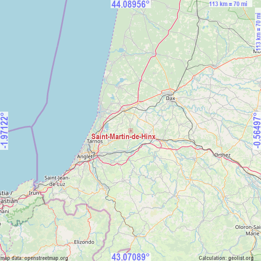
Saint-Martin-de-Hinx GPS coordinates[2]
43° 34' 56.568" North, 1° 16' 5.124" West
| Map corner | latitude | longitude |
|---|---|---|
| Upper-left | 44.08956°, | -1.97122° |
| Center: | 43.58238°, | -1.26809° |
| Lower-right: | 43.07089°, | -0.56497° |
| Map W x H: | 113.3×113.3 km | = 70.4×70.4mi |
| max Lat: | 51.07786° ⇑92% North |
| Saint-Martin-de-Hinx: | 43.58238° |
| min Lat: | ⇓8% South 41.3874° |
| min Long | Saint-Martin-de | max Long |
| -5.08615° | -1.26809° | 9.52242° |
| W 9.5%⇐ | ⇒90.5% E |
Elevation
Elevation of Saint-Martin-de-Hinx is 40 m = 131 ft, and this is 153.7 m = 504 ft below average elevation for this country.
| Max E: |
2333 m = 7654 ft | 85.9% |
| Avg. | 193.7 m = 635 ft | |
| Saint-Martin-de-Hinx | 40 m = 131 ft | |
Min E: |
-1 m = -3 ft | 14.1% |
See also: France elevation on elevation.city.
Geographical zone
Saint-Martin-de-Hinx is located in North temperate zone (between Tropic of Cancer and the Arctic Circle). Distance of this Northern Tropic circle is 2240 km =1391.9 mi to South.| Distance of | km | miles | from Saint-Martin-de-Hinx |
|---|---|---|---|
| North Pole | 5161.2 | 3207 | to North |
| Arctic Circle | 2555.3 | 1587.8 | to North |
| Tropic Cancer | 2240 | 1391.9 | to South |
| Equator | 4845.9 | 3011.1 | to South |


Nearby cities:
15 places around Saint-Martin-de-Hinx: (largest is in red/bold)
• Biaudos
4.7 km =2.9 mi,  221°
221°
• Bénesse-Maremne
9.4 km =5.8 mi,  309°
309°
• Guiche
9.4 km =5.8 mi,  147°
147°
• Josse
7.7 km =4.8 mi,  30°
30°
• Orist
9.9 km =6.2 mi,  48°
48°
• Orthevielle
10.2 km =6.3 mi,  109°
109°
• Pey
7.5 km =4.7 mi, 46°
• Port-de-Lanne
7.5 km =4.7 mi, 105°
• Saint-André-de-Seignanx
7.3 km =4.5 mi,  248°
248°
• Saint-Jean-de-Marsacq
4.9 km =3 mi,  10°
10°
• Saint-Laurent-de-Gosse
5.6 km =3.5 mi,  181°
181°
• Saint-Martin-de-Seignanx
10.7 km =6.6 mi, 245°
• Saint-Vincent-de-Tyrosse
9.2 km =5.7 mi,  339°
339°
• Saubrigues
4.8 km =3 mi, 309°
• Urt
10.5 km =6.5 mi,  192°
192°
Sources, notices
• [Note1] Compared only with cities in France existing in our database
• [Src1] Map data: © OpenStreetMap contributors (CC-BY-SA)
• [Src2] Other city data from geonames.org with taken over terms of usage.
• [Src3] Geographical zone / Annual Mean Temperature by Robert A. Rohde @ Wikipedia
