Guiche geodata
Guiche (Nouvelle-Aquitaine) is a populated place; located in France in Europe/Paris (GMT+2) time zone. With population of 781 people, there are 10811 cities with bigger population in this country. Compared to other cities in France, 92.9% of cities are located further ↑North; 90% of cities are located further →East and 64.4% of cities have higher elevation than Guiche. Note1
Administrative division(s):
- Level 1: Nouvelle-Aquitaine
- Level 2: Département des Pyrénées-Atlantiques
- Level 3: Arrondissement de Bayonne
- Level 4: Guiche


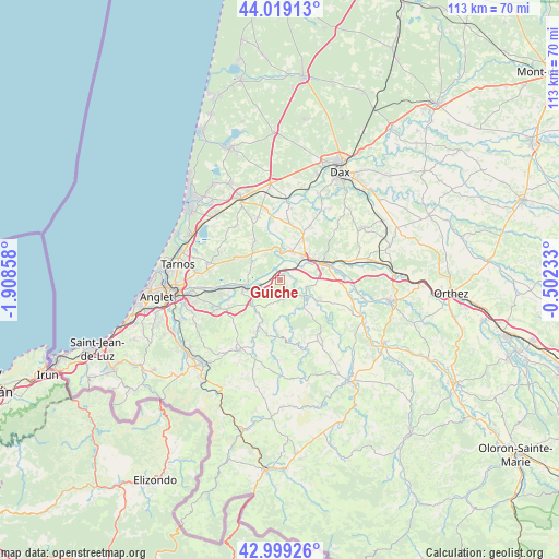
Guiche GPS coordinates[2]
43° 30' 40.86" North, 1° 12' 19.656" West
| Map corner | latitude | longitude |
|---|---|---|
| Upper-left | 44.01913°, | -1.90858° |
| Center: | 43.51135°, | -1.20546° |
| Lower-right: | 42.99926°, | -0.50233° |
| Map W x H: | 113.4×113.4 km | = 70.5×70.5mi |
| max Lat: | 51.07786° ⇑92.9% North |
| Guiche: | 43.51135° |
| min Lat: | ⇓7.1% South 41.3874° |
| min Long | Guiche | max Long |
| -5.08615° | -1.20546° | 9.52242° |
| W 10%⇐ | ⇒90% E |
Elevation
Elevation of Guiche is 91 m = 299 ft, and this is 102.7 m = 337 ft below average elevation for this country.
| Max E: |
2333 m = 7654 ft | 64.4% |
| Avg. | 193.7 m = 635 ft | |
| Guiche | 91 m = 299 ft | |
Min E: |
-1 m = -3 ft | 35.6% |
See also: France elevation on elevation.city.
Geographical zone
Guiche is located in North temperate zone (between Tropic of Cancer and the Arctic Circle). Distance of this Northern Tropic circle is 2232.1 km =1387 mi to South.| Distance of | km | miles | from Guiche |
|---|---|---|---|
| North Pole | 5169.1 | 3211.9 | to North |
| Arctic Circle | 2563.2 | 1592.7 | to North |
| Tropic Cancer | 2232.1 | 1387 | to South |
| Equator | 4838 | 3006.2 | to South |


Nearby cities:
15 places around Guiche: (largest is in red/bold)
• Bardos
4.2 km =2.6 mi,  177°
177°
• Biaudos
9.3 km =5.8 mi,  298°
298°
• Bidache
6.1 km =3.8 mi,  121°
121°
• Briscous
11.8 km =7.3 mi,  240°
240°
• Came
8.2 km =5.1 mi, 122°
• Cauneille
12.4 km =7.7 mi,  71°
71°
• Orthevielle
6.5 km =4 mi,  45°
45°
• Peyrehorade
8.3 km =5.2 mi,  60°
60°
• Port-de-Lanne
6.3 km =3.9 mi,  20°
20°
• Saint-André-de-Seignanx
12.9 km =8 mi,  293°
293°
• Saint-Laurent-de-Gosse
5.7 km =3.5 mi, 293°
• Saint-Lon-les-Mines
12.9 km =8 mi,  29°
29°
• Saint-Martin-de-Hinx
9.4 km =5.8 mi,  327°
327°
• Urcuit
11 km =6.8 mi,  255°
255°
• Urt
7.8 km =4.8 mi,  252°
252°
Sources, notices
• [Note1] Compared only with cities in France existing in our database
• [Src1] Map data: © OpenStreetMap contributors (CC-BY-SA)
• [Src2] Other city data from geonames.org with taken over terms of usage.
• [Src3] Geographical zone / Annual Mean Temperature by Robert A. Rohde @ Wikipedia
