Port-de-Lanne geodata
Port-de-Lanne (Nouvelle-Aquitaine) is a populated place; located in France in Europe/Paris (GMT+2) time zone. With population of 759 people, there are 11065 cities with bigger population in this country. Compared to other cities in France, 92.3% of cities are located further ↑North; 89.8% of cities are located further →East and 89.9% of cities have higher elevation than Port-de-Lanne. Note1
Administrative division(s):
- Level 1: Nouvelle-Aquitaine
- Level 2: Landes
- Level 3: Arrondissement de Dax
- Level 4: Port-de-Lanne


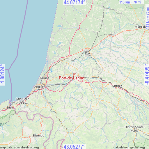
Port-de-Lanne GPS coordinates[2]
43° 33' 51.876" North, 1° 10' 41.196" West
| Map corner | latitude | longitude |
|---|---|---|
| Upper-left | 44.07174°, | -1.88124° |
| Center: | 43.56441°, | -1.17811° |
| Lower-right: | 43.05277°, | -0.47499° |
| Map W x H: | 113.3×113.3 km | = 70.4×70.4mi |
| max Lat: | 51.07786° ⇑92.3% North |
| Port-de-Lanne: | 43.56441° |
| min Lat: | ⇓7.7% South 41.3874° |
| min Long | Port-de-Lanne | max Long |
| -5.08615° | -1.17811° | 9.52242° |
| W 10.2%⇐ | ⇒89.8% E |
Elevation
Elevation of Port-de-Lanne is 30 m = 98 ft, and this is 163.7 m = 537 ft below average elevation for this country.
| Max E: |
2333 m = 7654 ft | 89.9% |
| Avg. | 193.7 m = 635 ft | |
| Port-de-Lanne | 30 m = 98 ft | |
Min E: |
-1 m = -3 ft | 10.1% |
See also: France elevation on elevation.city.
Geographical zone
Port-de-Lanne is located in North temperate zone (between Tropic of Cancer and the Arctic Circle). Distance of this Northern Tropic circle is 2238 km =1390.6 mi to South.| Distance of | km | miles | from Port-de-Lanne |
|---|---|---|---|
| North Pole | 5163.2 | 3208.3 | to North |
| Arctic Circle | 2557.3 | 1589 | to North |
| Tropic Cancer | 2238 | 1390.6 | to South |
| Equator | 4843.9 | 3009.9 | to South |


Nearby cities:
15 places around Port-de-Lanne: (largest is in red/bold)
• Bardos
10.3 km =6.4 mi,  191°
191°
• Biaudos
10.5 km =6.5 mi,  261°
261°
• Bidache
9.5 km =5.9 mi,  161°
161°
• Cagnotte
9.5 km =5.9 mi,  69°
69°
• Cauneille
9.7 km =6 mi,  101°
101°
• Guiche
6.3 km =3.9 mi,  200°
200°
• Josse
9.2 km =5.7 mi,  338°
338°
• Orist
8.5 km =5.3 mi,  1°
1°
• Orthevielle
2.8 km =1.7 mi,  119°
119°
• Pey
7.4 km =4.6 mi,  345°
345°
• Peyrehorade
5.3 km =3.3 mi,  108°
108°
• Saint-Jean-de-Marsacq
9.3 km =5.8 mi,  316°
316°
• Saint-Laurent-de-Gosse
8.3 km =5.2 mi,  244°
244°
• Saint-Lon-les-Mines
6.8 km =4.2 mi,  37°
37°
• Saint-Martin-de-Hinx
7.5 km =4.7 mi,  285°
285°
Sources, notices
• [Note1] Compared only with cities in France existing in our database
• [Src1] Map data: © OpenStreetMap contributors (CC-BY-SA)
• [Src2] Other city data from geonames.org with taken over terms of usage.
• [Src3] Geographical zone / Annual Mean Temperature by Robert A. Rohde @ Wikipedia
