Saint-Malo geodata
Saint-Malo (Brittany) is a seat of a third-order administrative division; located in France in Europe/Paris (GMT+2) time zone. With population of 50,676 people, there are 123 cities with bigger population in this country. Compared to other cities in France, 72% of cities are located further ↓South; 94.9% of cities are located further →East and 99.3% of cities have higher elevation than Saint-Malo. Note1
Administrative division(s):
- Level 1: Brittany
- Level 2: Département d'Ille-et-Vilaine
- Level 3: Arrondissement de Saint-Malo
- Level 4: Saint-Malo


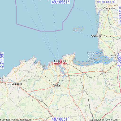
Saint-Malo GPS coordinates[2]
48° 38' 49.92" North, 2° 0' 31.788" West
| Map corner | latitude | longitude |
|---|---|---|
| Upper-left | 49.10961°, | -2.71195° |
| Center: | 48.6472°, | -2.00883° |
| Lower-right: | 48.18051°, | -1.3057° |
| Map W x H: | 103.3×103.3 km | = 64.2×64.2mi |
| max Lat: | 51.07786° ⇑28% North |
| Saint-Malo: | 48.6472° |
| min Lat: | ⇓72% South 41.3874° |
| min Long | Saint-Malo | max Long |
| -5.08615° | -2.00883° | 9.52242° |
| W 5.1%⇐ | ⇒94.9% E |
Elevation
Elevation of Saint-Malo is 5 m = 16 ft, and this is 188.7 m = 619 ft below average elevation for this country.
| Max E: |
2333 m = 7654 ft | 99.3% |
| Avg. | 193.7 m = 635 ft | |
| Saint-Malo | 5 m = 16 ft | |
Min E: |
-1 m = -3 ft | 0.7% |
See also: Saint-Malo elevation on elevation.city.
Geographical zone
Saint-Malo is located in North temperate zone (between Tropic of Cancer and the Arctic Circle). Distance of this North polar circle is 1992.1 km =1237.8 mi to North.| Distance of | km | miles | from Saint-Malo |
|---|---|---|---|
| North Pole | 4598 | 2857.1 | to North |
| Arctic Circle | 1992.1 | 1237.8 | to North |
| Tropic Cancer | 2803.1 | 1741.8 | to South |
| Equator | 5409.1 | 3361.1 | to South |


Nearby cities:
15 places around Saint-Malo: (largest is in red/bold)
• Châteauneuf-d’Ille-et-Vilaine
11.3 km =7 mi,  148°
148°
• Dinard
4.2 km =2.6 mi,  245°
245°
• La Gouesnière
9.7 km =6 mi,  119°
119°
• La Richardais
5 km =3.1 mi,  204°
204°
• Langrolay-sur-Rance
10.8 km =6.7 mi,  176°
176°
• Le Minihic-sur-Rance
7.7 km =4.8 mi, 179°
• Pleurtuit
8.4 km =5.2 mi,  205°
205°
• Saint-Briac-sur-Mer
9.6 km =6 mi, 253°
• Saint-Coulomb
7.8 km =4.8 mi,  67°
67°
• Saint-Jouan-des-Guérets
5.9 km =3.7 mi, 154°
• Saint-Lunaire
7.8 km =4.8 mi,  262°
262°
• Saint-Méloir-des-Ondes
7.7 km =4.8 mi,  97°
97°
• Saint-Père
9.1 km =5.7 mi,  136°
136°
• Saint-Suliac
9 km =5.6 mi,  162°
162°
• Tréméreuc
10.7 km =6.6 mi, 202°
Sources, notices
• [Note1] Compared only with cities in France existing in our database
• [Src1] Map data: © OpenStreetMap contributors (CC-BY-SA)
• [Src2] Other city data from geonames.org with taken over terms of usage.
• [Src3] Geographical zone / Annual Mean Temperature by Robert A. Rohde @ Wikipedia
