Saint-Coulomb geodata
Saint-Coulomb (Brittany) is a populated place; located in France in Europe/Paris (GMT+2) time zone. With population of 2,398 people, there are 4038 cities with bigger population in this country. Compared to other cities in France, 72.6% of cities are located further ↓South; 94.5% of cities are located further →East and 88.3% of cities have higher elevation than Saint-Coulomb. Note1
Administrative division(s):
- Level 1: Brittany
- Level 2: Département d'Ille-et-Vilaine
- Level 3: Arrondissement de Saint-Malo
- Level 4: Saint-Coulomb


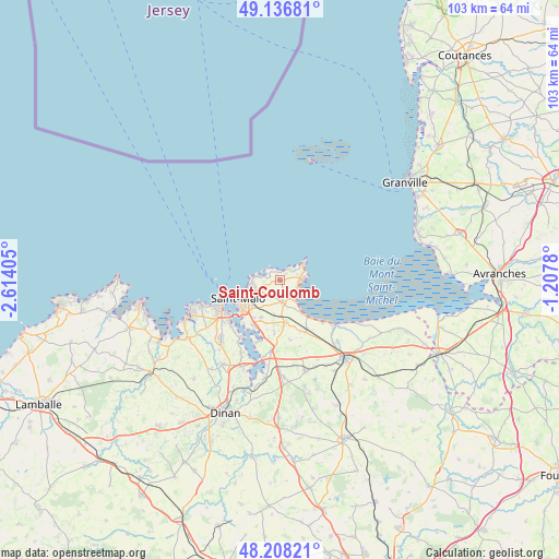
Saint-Coulomb GPS coordinates[2]
48° 40' 28.74" North, 1° 54' 39.312" West
| Map corner | latitude | longitude |
|---|---|---|
| Upper-left | 49.13681°, | -2.61405° |
| Center: | 48.67465°, | -1.91092° |
| Lower-right: | 48.20821°, | -1.2078° |
| Map W x H: | 103.3×103.2 km | = 64.2×64.1mi |
| max Lat: | 51.07786° ⇑27.4% North |
| Saint-Coulomb: | 48.67465° |
| min Lat: | ⇓72.6% South 41.3874° |
| min Long | Saint-Coulomb | max Long |
| -5.08615° | -1.91092° | 9.52242° |
| W 5.5%⇐ | ⇒94.5% E |
Elevation
Elevation of Saint-Coulomb is 34 m = 112 ft, and this is 159.7 m = 524 ft below average elevation for this country.
| Max E: |
2333 m = 7654 ft | 88.3% |
| Avg. | 193.7 m = 635 ft | |
| Saint-Coulomb | 34 m = 112 ft | |
Min E: |
-1 m = -3 ft | 11.7% |
See also: France elevation on elevation.city.
Geographical zone
Saint-Coulomb is located in North temperate zone (between Tropic of Cancer and the Arctic Circle). Distance of this North polar circle is 1989.1 km =1236 mi to North.| Distance of | km | miles | from Saint-Coulomb |
|---|---|---|---|
| North Pole | 4594.9 | 2855.1 | to North |
| Arctic Circle | 1989.1 | 1236 | to North |
| Tropic Cancer | 2806.2 | 1743.7 | to South |
| Equator | 5412.1 | 3362.9 | to South |


Nearby cities:
15 places around Saint-Coulomb: (largest is in red/bold)
• Cancale
4.3 km =2.7 mi,  87°
87°
• Châteauneuf-d’Ille-et-Vilaine
12.7 km =7.9 mi,  185°
185°
• Dinard
12.1 km =7.5 mi,  246°
246°
• Hirel
11.1 km =6.9 mi,  134°
134°
• La Fresnais
10.2 km =6.3 mi,  150°
150°
• La Gouesnière
7.9 km =4.9 mi,  170°
170°
• La Richardais
11.9 km =7.4 mi,  230°
230°
• Le Minihic-sur-Rance
12.9 km =8 mi,  213°
213°
• Saint-Benoît-des-Ondes
7.7 km =4.8 mi, 145°
• Saint-Guinoux
11.2 km =7 mi, 169°
• Saint-Jouan-des-Guérets
9.6 km =6 mi, 208°
• Saint-Malo
7.8 km =4.8 mi, 247°
• Saint-Méloir-des-Ondes
4.1 km =2.5 mi, 173°
• Saint-Père
9.8 km =6.1 mi, 185°
• Saint-Suliac
12.5 km =7.8 mi,  201°
201°
Sources, notices
• [Note1] Compared only with cities in France existing in our database
• [Src1] Map data: © OpenStreetMap contributors (CC-BY-SA)
• [Src2] Other city data from geonames.org with taken over terms of usage.
• [Src3] Geographical zone / Annual Mean Temperature by Robert A. Rohde @ Wikipedia
