Saint-Lô geodata
Saint-Lô (Normandy) is a seat of a second-order administrative division; located in France in Europe/Paris (GMT+2) time zone. With population of 21,722 people, there are 414 cities with bigger population in this country. Compared to other cities in France, 82.6% of cities are located further ↓South; 89.1% of cities are located further →East and 85.3% of cities have higher elevation than Saint-Lô. Note1
Administrative division(s):
- Level 1: Normandy
- Level 2: Manche
- Level 3: Arrondissement de Saint-Lô
- Level 4: Saint-Lô


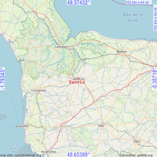
Saint-Lô GPS coordinates[2]
49° 6' 58.464" North, 1° 5' 25.116" West
| Map corner | latitude | longitude |
|---|---|---|
| Upper-left | 49.57432°, | -1.79343° |
| Center: | 49.11624°, | -1.09031° |
| Lower-right: | 48.65389°, | -0.38718° |
| Map W x H: | 102.3×102.3 km | = 63.6×63.6mi |
| max Lat: | 51.07786° ⇑17.4% North |
| Saint-Lô: | 49.11624° |
| min Lat: | ⇓82.6% South 41.3874° |
| min Long | Saint-Lô | max Long |
| -5.08615° | -1.09031° | 9.52242° |
| W 10.9%⇐ | ⇒89.1% E |
Elevation
Elevation of Saint-Lô is 41 m = 135 ft, and this is 152.7 m = 501 ft below average elevation for this country.
| Max E: |
2333 m = 7654 ft | 85.3% |
| Avg. | 193.7 m = 635 ft | |
| Saint-Lô | 41 m = 135 ft | |
Min E: |
-1 m = -3 ft | 14.7% |
See also: France elevation on elevation.city.
Geographical zone
Saint-Lô is located in North temperate zone (between Tropic of Cancer and the Arctic Circle). Distance of this North polar circle is 1940 km =1205.5 mi to North.| Distance of | km | miles | from Saint-Lô |
|---|---|---|---|
| North Pole | 4545.8 | 2824.6 | to North |
| Arctic Circle | 1940 | 1205.5 | to North |
| Tropic Cancer | 2855.3 | 1774.2 | to South |
| Equator | 5461.2 | 3393.4 | to South |


Nearby cities:
15 places around Saint-Lô: (largest is in red/bold)
• Agneaux
1.2 km =0.7 mi,  285°
285°
• Canisy
7.7 km =4.8 mi,  234°
234°
• Condé-sur-Vire
8.5 km =5.3 mi,  150°
150°
• Hébécrevon
5.7 km =3.5 mi,  282°
282°
• La Barre-de-Semilly
4.1 km =2.5 mi,  96°
96°
• La Mancellière-sur-Vire
5.4 km =3.4 mi,  164°
164°
• La Meauffe
6.9 km =4.3 mi,  347°
347°
• Pont-Hébert
6.5 km =4 mi,  330°
330°
• Saint-Georges-Montcocq
1.3 km =0.8 mi, 349°
• Saint-Gilles
6.4 km =4 mi,  258°
258°
• Saint-Jean-des-Baisants
8.9 km =5.5 mi,  106°
106°
• Saint-Romphaire
8.7 km =5.4 mi,  187°
187°
• Saint-Samson-de-Bonfossé
7.9 km =4.9 mi,  200°
200°
• Saint-Ébremond-de-Bonfossé
6.9 km =4.3 mi,  218°
218°
• Sainte-Suzanne-sur-Vire
6.4 km =4 mi, 159°
Sources, notices
• [Note1] Compared only with cities in France existing in our database
• [Src1] Map data: © OpenStreetMap contributors (CC-BY-SA)
• [Src2] Other city data from geonames.org with taken over terms of usage.
• [Src3] Geographical zone / Annual Mean Temperature by Robert A. Rohde @ Wikipedia
