Bouloc geodata
Bouloc (Occitanie) is a populated place; located in France in Europe/Paris (GMT+2) time zone. With population of 3,280 people, there are 2972 cities with bigger population in this country. Compared to other cities in France, 89.3% of cities are located further ↑North; 64.2% of cities are located further →East and 67% of cities have lower elevation than Bouloc. Note1
Administrative division(s):
- Level 1: Occitanie
- Level 2: Haute-Garonne
- Level 3: Arrondissement de Toulouse
- Level 4: Bouloc


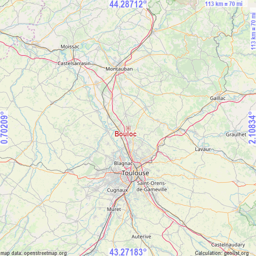
Bouloc GPS coordinates[2]
43° 46' 53.868" North, 1° 24' 18.792" East
| Map corner | latitude | longitude |
|---|---|---|
| Upper-left | 44.28712°, | 0.70209° |
| Center: | 43.78163°, | 1.40522° |
| Lower-right: | 43.27183°, | 2.10834° |
| Map W x H: | 112.9×112.9 km | = 70.2×70.2mi |
| max Lat: | 51.07786° ⇑89.3% North |
| Bouloc: | 43.78163° |
| min Lat: | ⇓10.7% South 41.3874° |
| min Long | Bouloc | max Long |
| -5.08615° | 1.40522° | 9.52242° |
| W 35.8%⇐ | ⇒64.2% E |
Elevation
Elevation of Bouloc is 204 m = 669 ft, and this is 10.3 m = 34 ft above average elevation for this country.
| Max E: |
2333 m = 7654 ft | 33% |
| Bouloc | 204 m 669 ft | |
| Avg. | 193.7 m = 635 ft | |
Min E: |
-1 m = -3 ft | 67% |
See also: France elevation on elevation.city.
Geographical zone
Bouloc is located in North temperate zone (between Tropic of Cancer and the Arctic Circle). Distance of this Northern Tropic circle is 2262.1 km =1405.6 mi to South.| Distance of | km | miles | from Bouloc |
|---|---|---|---|
| North Pole | 5139 | 3193.2 | to North |
| Arctic Circle | 2533.1 | 1574 | to North |
| Tropic Cancer | 2262.1 | 1405.6 | to South |
| Equator | 4868.1 | 3024.9 | to South |


Nearby cities:
15 places around Bouloc: (largest is in red/bold)
• Bruguières
6.1 km =3.8 mi,  178°
178°
• Castelnau-d'Estrétefonds
3.7 km =2.3 mi,  273°
273°
• Cépet
4.2 km =2.6 mi,  149°
149°
• Fronton
6.5 km =4 mi,  348°
348°
• Gargas
5.7 km =3.5 mi,  118°
118°
• Gratentour
6.8 km =4.2 mi,  161°
161°
• Labastide-Saint-Sernin
7.1 km =4.4 mi,  133°
133°
• Lespinasse
7.9 km =4.9 mi,  192°
192°
• Ondes
7.8 km =4.8 mi, 270°
• Saint-Jory
5.2 km =3.2 mi,  211°
211°
• Saint-Sauveur
3.7 km =2.3 mi, 185°
• Vacquiers
6.1 km =3.8 mi,  95°
95°
• Villariès
7.7 km =4.8 mi, 116°
• Villaudric
5.8 km =3.6 mi,  21°
21°
• Villeneuve-lès-Bouloc
2.1 km =1.3 mi,  137°
137°
Sources, notices
• [Note1] Compared only with cities in France existing in our database
• [Src1] Map data: © OpenStreetMap contributors (CC-BY-SA)
• [Src2] Other city data from geonames.org with taken over terms of usage.
• [Src3] Geographical zone / Annual Mean Temperature by Robert A. Rohde @ Wikipedia
