Borre geodata
Borre (Hauts-de-France) is a populated place; located in France in Europe/Paris (GMT+2) time zone. With population of 557 people, there are 14072 cities with bigger population in this country. Compared to other cities in France, 99% of cities are located further ↓South; 51.9% of cities are located further ←West and 88.3% of cities have higher elevation than Borre. Note1
Administrative division(s):
- Level 1: Hauts-de-France
- Level 2: Nord
- Level 3: Arrondissement de Dunkerque
- Level 4: Borre


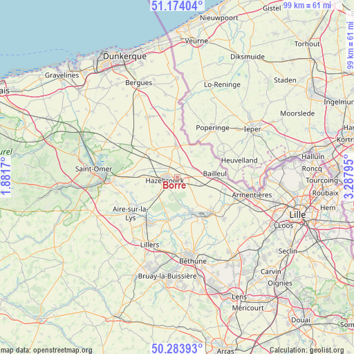
Borre GPS coordinates[2]
50° 43' 51.96" North, 2° 35' 5.352" East
| Map corner | latitude | longitude |
|---|---|---|
| Upper-left | 51.17404°, | 1.8817° |
| Center: | 50.7311°, | 2.58482° |
| Lower-right: | 50.28393°, | 3.28795° |
| Map W x H: | 99×99 km | = 61.5×61.5mi |
| max Lat: | 51.07786° ⇑1% North |
| Borre: | 50.7311° |
| min Lat: | ⇓99% South 41.3874° |
| min Long | Borre | max Long |
| -5.08615° | 2.58482° | 9.52242° |
| W 51.9%⇐ | ⇒48.1% E |
Elevation
Elevation of Borre is 34 m = 112 ft, and this is 159.7 m = 524 ft below average elevation for this country.
| Max E: |
2333 m = 7654 ft | 88.3% |
| Avg. | 193.7 m = 635 ft | |
| Borre | 34 m = 112 ft | |
Min E: |
-1 m = -3 ft | 11.7% |
See also: France elevation on elevation.city.
Geographical zone
Borre is located in North temperate zone (between Tropic of Cancer and the Arctic Circle). Distance of this North polar circle is 1760.4 km =1093.9 mi to North.| Distance of | km | miles | from Borre |
|---|---|---|---|
| North Pole | 4366.3 | 2713.1 | to North |
| Arctic Circle | 1760.4 | 1093.9 | to North |
| Tropic Cancer | 3034.9 | 1885.8 | to South |
| Equator | 5640.8 | 3505 | to South |


Nearby cities:
15 places around Borre: (largest is in red/bold)
• Caëstre
3.3 km =2.1 mi,  22°
22°
• Eecke
5.3 km =3.3 mi,  8°
8°
• Flêtre
5 km =3.1 mi,  57°
57°
• Godewaersvelde
8.2 km =5.1 mi,  30°
30°
• Hazebrouck
3.4 km =2.1 mi,  256°
256°
• Hondeghem
5.3 km =3.3 mi,  302°
302°
• Merris
5.7 km =3.5 mi,  107°
107°
• Morbecque
6.3 km =3.9 mi,  228°
228°
• Méteren
8.1 km =5 mi,  88°
88°
• Saint-Sylvestre-Cappel
5.4 km =3.4 mi,  338°
338°
• Sainte-Marie-Cappel
8.1 km =5 mi,  317°
317°
• Strazeele
3.3 km =2.1 mi,  99°
99°
• Terdeghem
8.2 km =5.1 mi, 337°
• Vieux-Berquin
5.8 km =3.6 mi,  133°
133°
• Wallon-Cappel
7.8 km =4.8 mi,  266°
266°
Sources, notices
• [Note1] Compared only with cities in France existing in our database
• [Src1] Map data: © OpenStreetMap contributors (CC-BY-SA)
• [Src2] Other city data from geonames.org with taken over terms of usage.
• [Src3] Geographical zone / Annual Mean Temperature by Robert A. Rohde @ Wikipedia
