Eecke geodata
Eecke (Hauts-de-France) is a populated place; located in France in Europe/Paris (GMT+2) time zone. With population of 901 people, there are 9647 cities with bigger population in this country. Compared to other cities in France, 99.2% of cities are located further ↓South; 52% of cities are located further ←West and 75.4% of cities have higher elevation than Eecke. Note1
Administrative division(s):
- Level 1: Hauts-de-France
- Level 2: Nord
- Level 3: Arrondissement de Dunkerque
- Level 4: Eecke


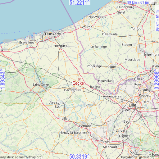
Eecke GPS coordinates[2]
50° 46' 42.996" North, 2° 35' 47.616" East
| Map corner | latitude | longitude |
|---|---|---|
| Upper-left | 51.2211°, | 1.89343° |
| Center: | 50.77861°, | 2.59656° |
| Lower-right: | 50.3319°, | 3.29968° |
| Map W x H: | 98.9×98.9 km | = 61.5×61.5mi |
| max Lat: | 51.07786° ⇑0.8% North |
| Eecke: | 50.77861° |
| min Lat: | ⇓99.2% South 41.3874° |
| min Long | Eecke | max Long |
| -5.08615° | 2.59656° | 9.52242° |
| W 52%⇐ | ⇒48% E |
Elevation
Elevation of Eecke is 66 m = 217 ft, and this is 127.7 m = 419 ft below average elevation for this country.
| Max E: |
2333 m = 7654 ft | 75.4% |
| Avg. | 193.7 m = 635 ft | |
| Eecke | 66 m = 217 ft | |
Min E: |
-1 m = -3 ft | 24.6% |
See also: France elevation on elevation.city.
Geographical zone
Eecke is located in North temperate zone (between Tropic of Cancer and the Arctic Circle). Distance of this North polar circle is 1755.1 km =1090.6 mi to North.| Distance of | km | miles | from Eecke |
|---|---|---|---|
| North Pole | 4361 | 2709.8 | to North |
| Arctic Circle | 1755.1 | 1090.6 | to North |
| Tropic Cancer | 3040.1 | 1889 | to South |
| Equator | 5646.1 | 3508.3 | to South |


Nearby cities:
15 places around Eecke: (largest is in red/bold)
• Berthen
6.9 km =4.3 mi,  85°
85°
• Boeschepe
7.7 km =4.8 mi,  71°
71°
• Borre
5.3 km =3.3 mi,  188°
188°
• Cassel
8.2 km =5.1 mi,  287°
287°
• Caëstre
2.3 km =1.4 mi,  169°
169°
• Flêtre
4.3 km =2.7 mi,  127°
127°
• Godewaersvelde
3.8 km =2.4 mi,  63°
63°
• Hazebrouck
7.4 km =4.6 mi,  214°
214°
• Hondeghem
5.9 km =3.7 mi,  245°
245°
• Saint-Sylvestre-Cappel
2.8 km =1.7 mi,  264°
264°
• Sainte-Marie-Cappel
6.3 km =3.9 mi,  275°
275°
• Steenvoorde
3.7 km =2.3 mi,  344°
344°
• Strazeele
6.3 km =3.9 mi,  157°
157°
• Terdeghem
4.6 km =2.9 mi,  299°
299°
• Winnezeele
7.6 km =4.7 mi, 335°
Sources, notices
• [Note1] Compared only with cities in France existing in our database
• [Src1] Map data: © OpenStreetMap contributors (CC-BY-SA)
• [Src2] Other city data from geonames.org with taken over terms of usage.
• [Src3] Geographical zone / Annual Mean Temperature by Robert A. Rohde @ Wikipedia
