Crevant-Laveine geodata
Crevant-Laveine (Auvergne-Rhône-Alpes) is a populated place; located in France in Europe/Paris (GMT+2) time zone. With population of 881 people, there are 9811 cities with bigger population in this country. Compared to other cities in France, 67.4% of cities are located further ↑North; 62.9% of cities are located further ←West and 82.8% of cities have lower elevation than Crevant-Laveine. Note1
Administrative division(s):
- Level 1: Auvergne-Rhône-Alpes
- Level 2: Département du Puy-de-Dôme
- Level 3: Arrondissement de Thiers
- Level 4: Crevant-Laveine


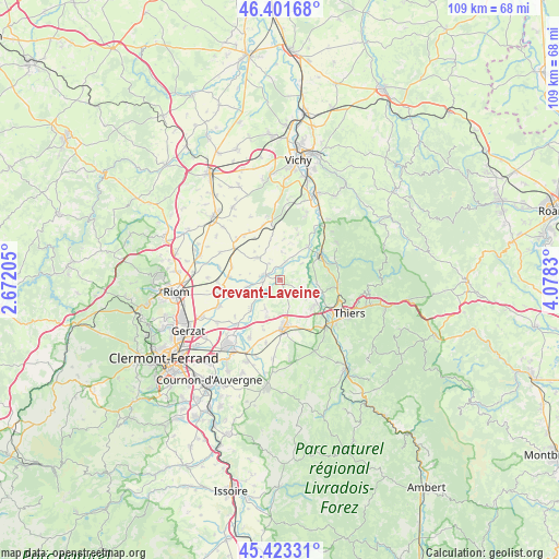
Crevant-Laveine GPS coordinates[2]
45° 54' 52.74" North, 3° 22' 30.612" East
| Map corner | latitude | longitude |
|---|---|---|
| Upper-left | 46.40168°, | 2.67205° |
| Center: | 45.91465°, | 3.37517° |
| Lower-right: | 45.42331°, | 4.0783° |
| Map W x H: | 108.8×108.8 km | = 67.6×67.6mi |
| max Lat: | 51.07786° ⇑67.4% North |
| Crevant-Laveine: | 45.91465° |
| min Lat: | ⇓32.6% South 41.3874° |
| min Long | Crevant-Laveine | max Long |
| -5.08615° | 3.37517° | 9.52242° |
| W 62.9%⇐ | ⇒37.1% E |
Elevation
Elevation of Crevant-Laveine is 320 m = 1050 ft, and this is 126.3 m = 414 ft above average elevation for this country.
| Max E: |
2333 m = 7654 ft | 17.2% |
| Crevant-Laveine | 320 m 1050 ft | |
| Avg. | 193.7 m = 635 ft | |
Min E: |
-1 m = -3 ft | 82.8% |
See also: France elevation on elevation.city.
Geographical zone
Crevant-Laveine is located in North temperate zone (between Tropic of Cancer and the Arctic Circle). Distance of this North polar circle is 2295.9 km =1426.6 mi to North.| Distance of | km | miles | from Crevant-Laveine |
|---|---|---|---|
| North Pole | 4901.8 | 3045.8 | to North |
| Arctic Circle | 2295.9 | 1426.6 | to North |
| Tropic Cancer | 2499.3 | 1553 | to South |
| Equator | 5105.2 | 3172.2 | to South |


Nearby cities:
15 places around Crevant-Laveine: (largest is in red/bold)
• Culhat
6.5 km =4 mi,  207°
207°
• Dorat
8.6 km =5.3 mi,  106°
106°
• Ennezat
11.9 km =7.4 mi,  260°
260°
• Entraigues
9.3 km =5.8 mi,  252°
252°
• Joze
8 km =5 mi,  224°
224°
• Lezoux
9.8 km =6.1 mi,  178°
178°
• Limons
8.5 km =5.3 mi,  39°
39°
• Luzillat
3.7 km =2.3 mi,  18°
18°
• Maringues
3.6 km =2.2 mi,  282°
282°
• Orléat
7 km =4.3 mi,  149°
149°
• Paslières
9.6 km =6 mi,  80°
80°
• Puy-Guillaume
9.2 km =5.7 mi,  56°
56°
• Randan
11.6 km =7.2 mi,  352°
352°
• Saint-Ignat
7.8 km =4.8 mi, 276°
• Thuret
10.8 km =6.7 mi,  303°
303°
Sources, notices
• [Note1] Compared only with cities in France existing in our database
• [Src1] Map data: © OpenStreetMap contributors (CC-BY-SA)
• [Src2] Other city data from geonames.org with taken over terms of usage.
• [Src3] Geographical zone / Annual Mean Temperature by Robert A. Rohde @ Wikipedia
