Saint-Georges-des-Coteaux geodata
Saint-Georges-des-Coteaux (Nouvelle-Aquitaine) is a populated place; located in France in Europe/Paris (GMT+2) time zone. With population of 2,198 people, there are 4372 cities with bigger population in this country. Compared to other cities in France, 69.8% of cities are located further ↑North; 85.7% of cities are located further →East and 82.2% of cities have higher elevation than Saint-Georges-des-Coteaux. Note1
Administrative division(s):
- Level 1: Nouvelle-Aquitaine
- Level 2: Charente-Maritime
- Level 3: Arrondissement de Saintes
- Level 4: Saint-Georges-des-Coteaux
Current local time in Saint-Georges-des-Coteaux:
02:04 PM, SaturdayDifference from your time zone: hours


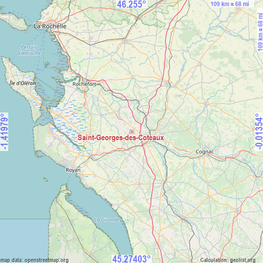
Saint-Georges-des-Coteaux GPS coordinates[2]
45° 46' 0.012" North, 0° 43' 0.012" West
| Map corner | latitude | longitude |
|---|---|---|
| Upper-left | 46.255°, | -1.41979° |
| Center: | 45.76667°, | -0.71667° |
| Lower-right: | 45.27403°, | -0.01354° |
| Map W x H: | 109.1×109.1 km | = 67.8×67.8mi |
| max Lat: | 51.07786° ⇑69.8% North |
| Saint-Georges-des-Coteaux: | 45.76667° |
| min Lat: | ⇓30.2% South 41.3874° |
| min Long | Saint-Georges-d | max Long |
| -5.08615° | -0.71667° | 9.52242° |
| W 14.3%⇐ | ⇒85.7% E |
Elevation
Elevation of Saint-Georges-des-Coteaux is 49 m = 161 ft, and this is 144.7 m = 475 ft below average elevation for this country.
| Max E: |
2333 m = 7654 ft | 82.2% |
| Avg. | 193.7 m = 635 ft | |
| Saint-Georges-des-Coteaux | 49 m = 161 ft | |
Min E: |
-1 m = -3 ft | 17.8% |
See also: France elevation on elevation.city.
Geographical zone
Saint-Georges-des-Coteaux is located in North temperate zone (between Tropic of Cancer and the Arctic Circle). Distance of this North polar circle is 2312.4 km =1436.9 mi to North.| Distance of | km | miles | from Saint-Georges-des-Coteaux |
|---|---|---|---|
| North Pole | 4918.3 | 3056.1 | to North |
| Arctic Circle | 2312.4 | 1436.9 | to North |
| Tropic Cancer | 2482.9 | 1542.8 | to South |
| Equator | 5088.8 | 3162 | to South |


Nearby cities:
15 places around Saint-Georges-des-Coteaux: (largest is in red/bold)
• Bussac-sur-Charente
6.7 km =4.2 mi,  74°
74°
• Chermignac
9.6 km =6 mi,  159°
159°
• Corme-Royal
8 km =5 mi,  251°
251°
• Fontcouverte
10.1 km =6.3 mi,  89°
89°
• Les Essards
4.3 km =2.7 mi,  310°
310°
• Les Gonds
9.9 km =6.2 mi,  126°
126°
• Nieul-lès-Saintes
1.3 km =0.8 mi,  237°
237°
• Pessines
4.4 km =2.7 mi,  180°
180°
• Plassay
5.8 km =3.6 mi,  353°
353°
• Rétaud
9.9 km =6.2 mi, 184°
• Saint-Porchaire
7.9 km =4.9 mi,  319°
319°
• Saintes
6.8 km =4.2 mi,  110°
110°
• Soulignonne
5.6 km =3.5 mi,  282°
282°
• Taillebourg
9.3 km =5.8 mi,  36°
36°
• Varzay
6.8 km =4.2 mi,  189°
189°
Sources, notices
• [Note1] Compared only with cities in France existing in our database
• [Src1] Map data: © OpenStreetMap contributors (CC-BY-SA)
• [Src2] Other city data from geonames.org with taken over terms of usage.
• [Src3] Geographical zone / Annual Mean Temperature by Robert A. Rohde @ Wikipedia
